
Guna Yala’s island comarca and the gateway of El Porvenir
Published on 09/19/2026 at 12:13 | Editorial responsibility: Rafael Müller, Editor-in-Chief AD HOC NEWS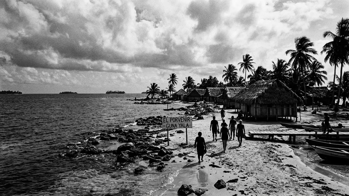
Guna Yala is an indigenous territory on Panama’s Caribbean coast where hundreds of coral islands, narrow mainland jungle and the daily life of the Guna people form a single, continuous landscape. The comarca, formally recognised as part of Panama yet governed by its own institutions, stretches along the shore opposite El Porvenir and out across the shallow sea.
An island archipelago shaped by coral and Caribbean light
The most immediate image of Guna Yala is the scatter of low islands lying off the north coast of Panama east of the Panama Canal, a formation often referred to in English as the San Blas Islands.San Blas Islands of Panama These islands belong to the wider comarca of Guna Yala, which combines offshore cays with a strip of mainland that faces the Caribbean Sea.comarca indígena in northeast Panama Many of the islands are built up with timber houses, meeting houses and simple jetties that reach over shallow water where boats tie up directly against the edge of the settlement.
Across the comarca there are hundreds of islands, a minority of them inhabited by permanent communities that maintain their own leadership and customary rules.365 islands strung along Panama's coast Palm trees rise above roofs and sandy paths, and in many places the land stands only slightly above sea level, so that views are defined as much by open water and sky as by solid ground. From the western end near El Porvenir to the more remote eastern cays, the archipelago creates a band of small-scale habitation set within broad expanses of reef and lagoon.
Guna Yala as an autonomous indigenous comarca
Politically, Guna Yala is a comarca indígena, an indigenous province within Panama whose administration is defined by specific national laws and its own statutes.special regime established by law The name “Guna Yala” itself is the official term for the region, adopted to reflect the identity and language of the Guna people in place of the older “San Blas”.official name for the region is Guna Yala It is bounded on the north by the Caribbean Sea and on the south by the provinces and comarcas that mark the transition towards Panama’s interior forests.bounded on the north by the Caribbean Sea
The territory covers more than 2,300 km² (around 890 sq mi), taking in both mainland and island areas under a single indigenous jurisdiction.2307,6 km² autonomous Gebiet A population numbering in the tens of thousands lives across its communities, the large majority of them Guna by origin.over 32,000 people live here Within Panama’s political map, Guna Yala appears as an elongated coastal band running for more than 300 km (over 186 mi) between the province of Colón in the west and the border with Colombia in the east.limits with Colón and Colombia
El Porvenir and Gaigirgordub: gateways to the islands
El Porvenir is the name widely used in travel writing for the administrative capital island of Guna Yala, a small, narrow island off the tip of the mainland peninsula at the western end of the comarca.administrative capital, El Porvenir On official records, the capital is Gaigirgordub, a settlement that has inherited the governmental role previously associated with El Porvenir while remaining closely linked with the same coastal area.capital is Gairgirgordub (antigua El Porvenir) Offices serving the comarca and facilities such as the airstrip and pier concentrate on this side of Guna Yala, making it one of the principal points of contact between the islands and the rest of Panama.
Travel descriptions consistently portray El Porvenir as a built-up administrative centre rather than a broad beach, with its land area largely occupied by government buildings, houses and infrastructure that support movement out into the archipelago.administrative capital of Guna Yala and gateway From here, boats run to neighbouring islands, and small aircraft connect the comarca with the rest of Panama via coastal airstrips.
Visiting Guna Yala: what travellers from Western Europe should know
- Guna Yala lies off Panama’s north-east Caribbean coast; El Porvenir and Gaigirgordub stand on a small island at the western end, reached by road-and-boat combinations and local flights across Panama.
- Much of the terrain consists of low-lying coral islands and narrow mainland jungle; access to settlements generally involves walking along sandy paths and simple jetties rather than paved promenades.
- The official language is Spanish and the currency is the Panamanian balboa, which circulates alongside the United States dollar as legal tender in Panama.
- Guna Yala is part of Panama but governed as an indigenous comarca, so entry requirements depend on your nationality; UK travellers can check the FCDO travel advice at gov.uk/foreign-travel-advice, Irish travellers the Department of Foreign Affairs at ireland.ie.
Searching for Guna Yala on social platforms
These links open searches for Guna Yala on each platform.
Frequently asked questions about Guna Yala
Where is Guna Yala in relation to El Porvenir and the rest of Panama?
Guna Yala runs along Panama’s north-east Caribbean coast, with El Porvenir and Gaigirgordub on a small capital island at its western end close to the mainland.
What kind of landscape and settlements should visitors expect?
The comarca combines mainland jungle and hundreds of coral islands; inhabited islands tend to be densely built with timber houses, meeting houses and simple waterfronts.
What makes Guna Yala distinctive among Panama’s regions?
Guna Yala is an indigenous comarca with its own administration, a coastal and island territory where Guna communities shape both local governance and daily life on the Caribbean.


