
Guna Yala and El Porvenir, where an island capital meets an indigenous sea
Published on 08/20/2026 at 09:48 | Editorial responsibility: Rafael Müller, Editor-in-Chief AD HOC NEWS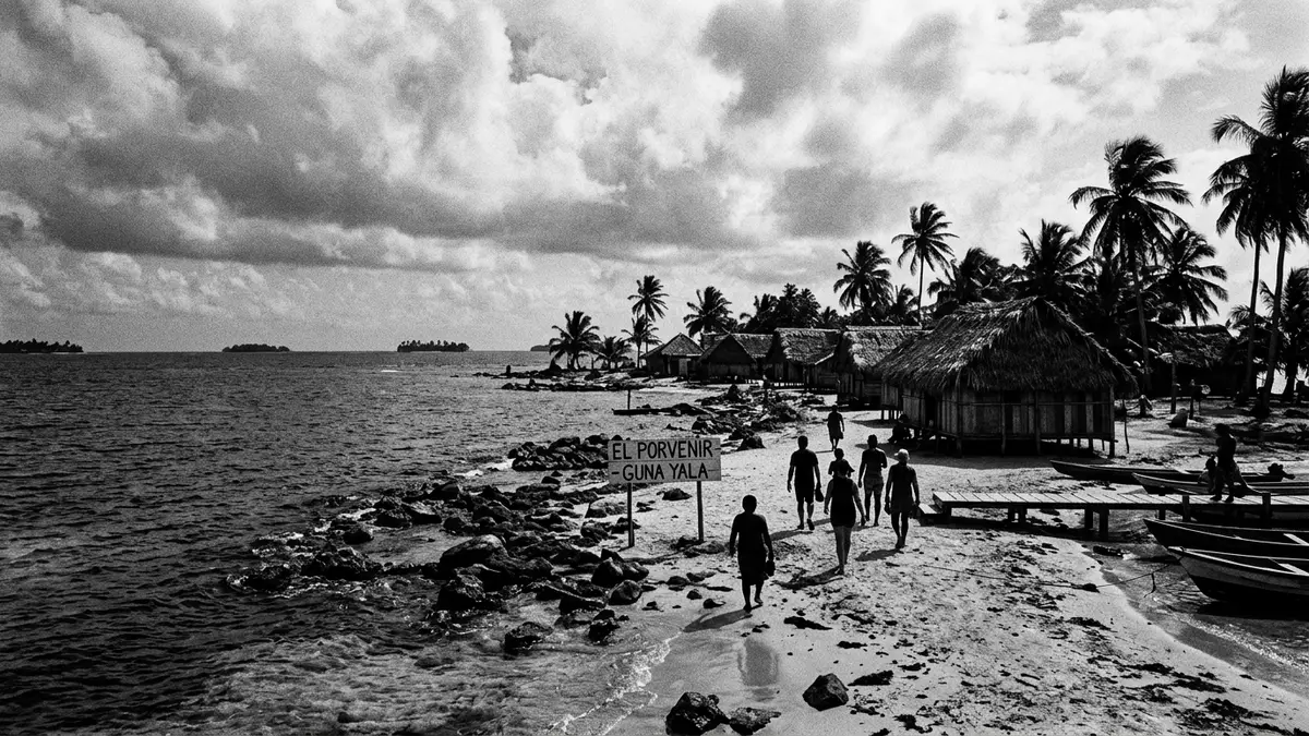
Guna Yala is an autonomous indigenous territory on the Caribbean coast of Panama, a narrow strip of mainland backed by rainforest and an archipelago of low islands scattered across the sea. The capital for administrative purposes, El Porvenir, lies on a small island at the western edge of the territory, and acts as a compact gateway between the Guna communities and travellers arriving from the rest of Panama.
An indigenous comarca of sea, islands and forest
Guna Yala is formally designated as a comarca indígena, an indigenous province recognised within Panama’s political system and controlled by the Guna people themselves.indigenous province The territory occupies the north-eastern coast of Panama, facing the Caribbean Sea to the north and reaching towards the border with Colombia in the east, while inland it meets the Darién region and other Panamanian provinces along the forested foothills.north-eastern coast of Panama This coastal band is relatively narrow on the mainland, but the jurisdiction extends far out into the water to include a large archipelago.
The islands of Guna Yala are frequently referred to outside Panama as the San Blas Islands, a foreign name that persists alongside the official designation and reflects a long history of encounters between local communities and visiting ships.foreigners name for the region Most Guna communities are organised on small islands lying just offshore from the mainland, with houses, communal buildings and jetties clustered close together above sand and coral.communities on small islands From El Porvenir, boats spread out towards these islands, reinforcing the practical importance of the capital as a meeting point between different parts of the territory.
El Porvenir and the structure of Guna self-government
Within Guna Yala, El Porvenir serves as the administrative capital, a status reflected in official listings and some statistical descriptions of the comarca.administrative capital El Porvenir The town occupies a narrow island close to the mainland peninsula at the western end of the archipelago, and combines governmental buildings, an airstrip and basic services in a compact space.small narrow island off the peninsula Older records name El Porvenir as the capital, while more recent documentation highlights Gaigirgordub, also known as Gairgirgordub, as the centre of administration, reflecting changes in internal organisation and naming conventions over time.Gaigirgordub as capital
Guna Yala has been known under several names, including San Blas and Kuna Yala, before the present form of the name was adopted by the community and recognised by the Panamanian state.San Blas and Kuna Yala The Guna have retained a significant degree of political autonomy, expressed through internal institutions such as the general congress that represents communities across the territory and exercises authority over land, sea and cultural matters.self-determined governing structures For visitors, El Porvenir is both an entry point and a symbol of this autonomy: a small island where local governance, indigenous identity and links to the wider Panamanian state intersect.
Islands, culture and everyday life in Guna Yala
The Guna people, sometimes written as Kuna or Cuna, live not only in Guna Yala but also in other autonomous territories in Panama and a handful of communities in Colombia, though the archipelago off the Caribbean coast remains closely associated with their name.Guna people across territories Within the comarca, Guna settlements range from densely built islands to small mainland villages along the coast, and are organised around communal halls, family dwellings and meeting spaces that reflect collective traditions. Many accounts emphasise the presence of matrilineal structures and strong roles for women in community life, alongside distinctive clothing and textile art that visually mark the territory’s culture.matrilineal structures
The islands themselves stand out for their low elevation, sandy ground and fringes of palm trees set against shallow water and coral reefs, with some islands hosting compact settlements and others left as uninhabited strips of sand and vegetation.archipelago of approximately 365 islands On the mainland side of Guna Yala, dense forest rises behind the coastal strip, forming part of a wider belt of tropical rainforest that stretches across eastern Panama.rainforest on the mainland coast This combination of sea, reef and forest gives the territory a distinctive landscape, with El Porvenir sitting at the junction of maritime routes and flights that arrive from elsewhere in Panama to an airstrip on its island.airstrip receiving flights from Panama City
Visiting Guna Yala: what travellers from Western Europe should know
- Guna Yala lies along the north-eastern Caribbean coast of Panama, with El Porvenir on a small island at the western end of the archipelago, reachable by domestic flight and onward boat from other parts of Panama.
- The terrain combines low sandy islands and shallow coastal waters with a forested mainland; on El Porvenir visitors encounter jetties, simple buildings and an airstrip concentrated on a narrow strip of land.
- English is not an official language; the official language is Spanish and the currency is the Panamanian balboa, which circulates alongside the United States dollar in everyday transactions.
- Entry requirements depend on your nationality; UK travellers can check the FCDO travel advice at gov.uk/foreign-travel-advice, Irish travellers the Department of Foreign Affairs at ireland.ie.
Searching for Guna Yala on social platforms
These links open searches for Guna Yala on each platform.
Frequently asked questions about Guna Yala
Where is Guna Yala in relation to the rest of Panama?
Guna Yala occupies the north-eastern Caribbean coast of Panama, stretching along the mainland shore and encompassing an offshore archipelago of islands towards the Colombian border.
What can visitors expect when arriving in El Porvenir?
El Porvenir is a small island settlement with administrative buildings and an airstrip, from which boats depart towards Guna communities on nearby islands and along the coast.
What makes Guna Yala distinctive compared with other coastal regions?
The combination of Guna political autonomy, an officially recognised indigenous comarca, and a landscape where low islands and dense rainforest meet across sea and mainland gives Guna Yala its particular character.


