
Geirangerfjorden and the cliff farms above the deep blue fjord
Published on 08/27/2026 at 20:31 | Editorial responsibility: Rafael Müller, Editor-in-Chief AD HOC NEWS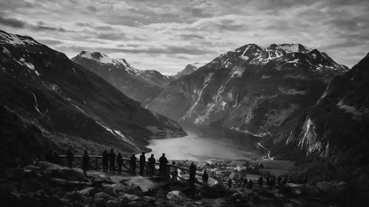
Geirangerfjorden in western Norway is a deep, narrow branch of the Storfjord where a small village, steep mountains and abandoned cliff farms meet in a single dramatic corridor. In 2005 the fjord, together with the Nærøyfjord, was placed on the UNESCO World Heritage List as part of the West Norwegian Fjords for its outstanding natural scenery and geology.
A fjord carved between mountains and farms
Geirangerfjorden lies in the municipality of Stranda in the county of Møre og Romsdal, at the inner end of a branch of the Storfjord that cuts inland from the Norwegian Sea.West Norwegian Fjords The fjord forms a long, sinuous waterway, with the village of Geiranger at its landward head and the settlement of Hellesylt lying out towards the open sea. The water reaches significant depths while mountains rise sharply above, so that from the deck of a boat the surrounding slopes appear to grow directly from the fjord.
Along these slopes sit the remains of cliff farms such as Skageflå and Knivsflå, which were once reached by footpaths and ladders cut into the rock.cliff farms such as Skageflå Their hayfields and buildings occupy small shelves high above the water, demonstrating how families adapted to the limited flat ground in this valley. The contrast between the calm surface of the fjord and the precarious positions of these farms is one of the defining impressions of Geirangerfjorden’s landscape.
UNESCO recognition for the West Norwegian Fjords
In July 2005 the West Norwegian Fjords, comprising Geirangerfjorden and Nærøyfjorden, were inscribed on the UNESCO World Heritage List under criteria for natural beauty and geological significance.inscribed on the UNESCO World Heritage List The inscription covers an area that includes the inner parts of both fjords and the surrounding mountains, valleys and high plateaus. Within this property the Geirangerfjord area accounts for more than 50,000 hectares of land and sea, with the fjord itself forming the central feature.Geirangerfjord area accounts for more than 50,000 hectares
The designation recognises the way glaciers from the last Ice Age carved deep troughs into the bedrock, later flooded by the sea to create fjords, while leaving hanging valleys and steep rock faces above. In Geirangerfjorden this geology is easy to read: waterfalls plunge from high ledges, moraines and scree slopes run down to the shore, and the valley narrows towards Geiranger so that the waterway feels enclosed by rock on both sides.
Waterfalls and viewpoints over Geirangerfjorden
Several major waterfalls line the sides of Geirangerfjorden, with the Seven Sisters (Dei Sju Systrene) among the best known.Seven Sisters (Dei Sju Systrene) This waterfall consists of multiple parallel streams dropping from a high cliff on the northern side of the fjord, with the historic Knivsflå farm nearby on a terrace above. Across the water stands another waterfall often referred to as “the Suitor”, so that on a boat trip the two cascades appear to face each other across the fjord.
On land, the Flydalsjuvet viewpoint provides one of the classic elevated views of Geirangerfjorden.Flydalsjuvet viewpoint At this point the road up from Geiranger reaches a rock promontory with platforms that look back down over the village, the waterway and the cruise ships below. Another vantage point higher in the mountains is Dalsnibba, where a mountain road climbs to a summit above the tree line and a viewing area looks across to Geirangerfjorden and the surrounding peaks.
Visiting Geirangerfjorden: what travellers from Western Europe should know
- Geirangerfjorden lies in the county of Møre og Romsdal in western Norway, with the village of Geiranger at the head of the fjord and Hellesylt further out along the same waterway.
- The fjord is reached by road along National Route 63 from the surrounding valleys, and by ferries and other boats that run along the Storfjord between Hellesylt, Geiranger and other settlements.
- The surrounding terrain rises sharply from the shoreline, with roads climbing in hairpin bends and viewpoints such as Flydalsjuvet and Dalsnibba reached along mountain roads that gain significant height in a short distance.
- Walking routes above the fjord include paths to former farms and viewpoints, where tracks can cross uneven rock, forest trails and steep sections that require sure footing.
- The official language is Norwegian and the currency is the Norwegian krone.
Searching for Geirangerfjorden on social platforms
These links open searches for Geirangerfjorden on each platform.
Frequently asked questions about Geirangerfjorden
Where is Geirangerfjorden located?
Geirangerfjorden is a branch of the Storfjord in Møre og Romsdal county in western Norway, with the village of Geiranger at its innermost end.
What can visitors expect on a visit to Geirangerfjorden?
Visitors encounter steep mountains, deep water, waterfalls such as the Seven Sisters and views from cliff-edge farms and roadside viewpoints over the fjord and the village below.
What makes Geirangerfjorden distinctive among fjords?
Geirangerfjorden is part of a UNESCO World Heritage Site where glacially carved rock walls, cliff farms and major waterfalls combine in a compact valley that remains largely shaped by natural forces.


