
Galle Fort and the walled old town by the Indian Ocean
Published on 09/09/2026 at 06:16 | Editorial responsibility: Rafael Müller, Editor-in-Chief AD HOC NEWS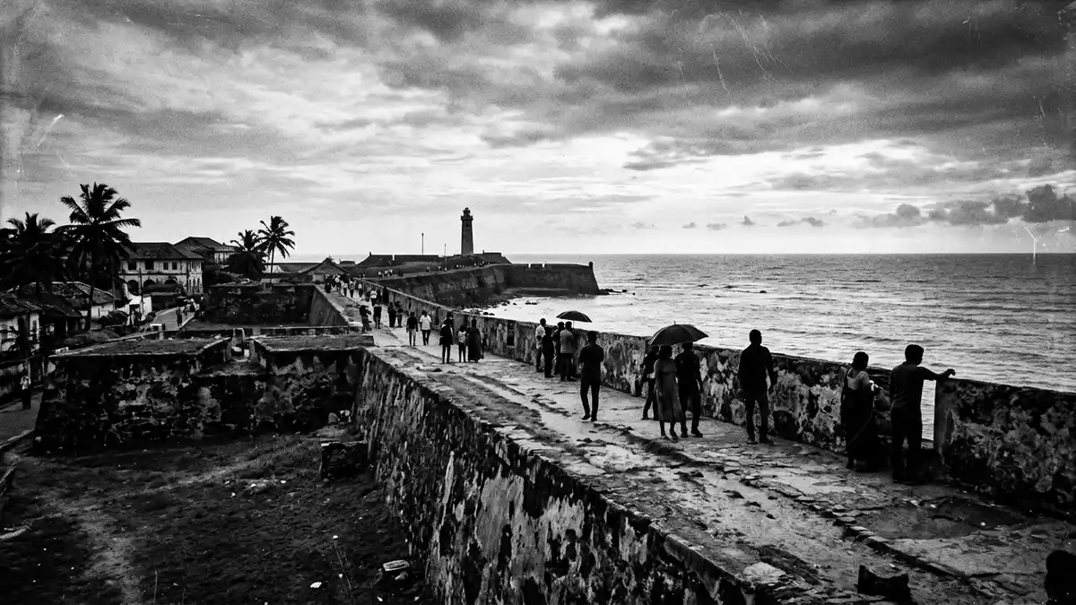
On the south-west coast of Sri Lanka, Galle Fort turns a rocky peninsula at Galle into a walled old town of ramparts, bastions and narrow streets shaped by centuries of colonial rule. Founded as a fortified settlement by the Portuguese in the late sixteenth century and rebuilt on a grand scale by Dutch engineers in the seventeenth century, it is recognised by UNESCO as the “Old Town of Galle and its Fortifications”, a cultural World Heritage Site exemplifying the encounter of European and South Asian architecture between the sixteenth and nineteenth centuries.Old Town of Galle and its Fortifications
A stone-walled town above the sea
Galle Fort occupies a rocky headland projecting into the Bay of Galle, its perimeter defined by high stone and coral ramparts that enclose a self-contained townscape distinct from the modern city outside.Bay of Galle on the southwest coast Within those walls, streets laid out in a grid during the Dutch period are lined with houses, warehouses, religious buildings and public institutions that reflect successive Portuguese, Dutch and British occupations.developed successively by Portuguese, Dutch and British imperial forces The fortification system, largely completed in the seventeenth century, surrounds an area measured at about 52 hectares, defended by a series of named bastions that face both land and sea.an area of 52 hectares defended by altogether 14 bastions
The ramparts rise above waves that break against the rocks below the walls, with broad walkways on top giving long views over the Indian Ocean and back into the grid of streets. At key points, stone bastions project from the walls, marking the positions where artillery once guarded the entrance to the harbour and the landward approaches. Behind the fortifications, the town interior is relatively low-rise, so the contrast between the heavy outer walls and the intimate lanes within is clear even to a casual visitor.
Layers of Portuguese, Dutch and British rule
In the late sixteenth century the Portuguese strengthened Galle as a fortified port and trading post, constructing an early fortress that they named Santa Cruz.Portuguese first built a small fortress at Galle in 1588 The fort was captured in 1640 by the Dutch East India Company, allied with the Kandyan king Rajasinhe II, after a siege that left a lasting mark in Dutch sayings about the cost of the operation.captured in 1640 by the Dutch East India Company Dutch engineers then undertook an extensive rebuilding, enclosing the whole headland within solid ramparts and bastions, and laying out the straight streets and drainage that still define the fort’s structure.fortified city built during the Dutch period In 1796, control passed to the British, who used Galle as an administrative and maritime centre in the south while making relatively few alterations to the main fortifications.captured by the British in 1796
These successive colonial layers are legible in the buildings within the walls. Dutch-period houses with lintelled doorways, columned verandas and terracotta roofs stand beside British-era public buildings such as the clock tower and courthouse. Churches in European styles sit close to mosques and Buddhist temples, reflecting the religious diversity that persisted within a town shaped by European powers. The overall plan, however, remains largely that of the seventeenth-century Dutch fortified city, a reason why Galle Fort is described as one of the most intact colonial walled towns in Asia.a whole seventeenth-century walled town of ramparts, cobbled lanes, churches and villas
Architecture, bastions and UNESCO recognition
The UNESCO inscription for the “Old Town of Galle and its Fortifications” dates from 1988 and is framed under criterion (iv), which highlights the site as an urban ensemble showing interaction between European architecture and South Asian traditions from the sixteenth to the nineteenth centuries.inscribed as a cultural heritage UNESCO World Heritage Site under criteria iv The fortified perimeter consists of continuous stone walls with a sequence of bastions, including those known today as Star, Moon and Sun bastions on the northern side, whose foundations reach back to Portuguese defences named after saints.Northern Ramparts bastions with original and current names Within the walls, Dutch Reformed Church buildings, a British-built lighthouse from the nineteenth century and the Meeran Jumma Mosque stand as prominent landmarks, while smaller houses and warehouses line the streets.British lighthouse, Dutch Reformed Church and Meeran Jumma Mosque
Materials used in the fortifications include granite blocks and coral stone, reflecting both local geology and imported construction techniques.incorporating the site’s natural topography Street façades show shutters, arched entrances and colonnades that derive from Dutch and British architectural languages but are adapted to the climate and customs of the island. The result is a built environment where European town-planning principles, such as rectilinear blocks and axial views along streets, coexist with South Asian residential forms and religious sites, justifying UNESCO’s emphasis on intercultural architectural dialogue at Galle Fort.interaction of European architecture and South Asian traditions
Visiting Galle Fort: what travellers from Western Europe should know
- Galle Fort stands within the city of Galle on Sri Lanka’s south-west coast, reached over the main coastal road and served by Galle railway station and regional bus services.
- The fort’s interior is largely level but the ramparts rise above the sea on masonry walls; reaching the top involves climbing stone steps and walking along broad paths exposed to sun and wind.
- Within the enclosed area, streets form a compact grid; exploring the town on foot means frequent turns, short distances between landmarks and occasional uneven paving on older lanes.
- The official language is Sinhala and the currency is the Sri Lankan rupee.
- Entry requirements depend on your nationality; UK travellers can check the FCDO travel advice at gov.uk/foreign-travel-advice, Irish travellers the Department of Foreign Affairs at ireland.ie.
Searching for Galle Fort on social platforms
These links open searches for Galle Fort on each platform.
Frequently asked questions about Galle Fort
Where is Galle Fort located?
Galle Fort is a walled old town on a headland in the Bay of Galle on Sri Lanka’s south-west coast, forming part of the city of Galle.
What should visitors expect inside the fort?
Inside the walls, visitors encounter a grid of streets lined with colonial-era houses, churches, mosques and public buildings, with ramparts, bastions and sea views reachable on foot.
What makes Galle Fort distinctive among historic towns?
Galle Fort is distinctive for its seventeenth-century fortified perimeter, its Dutch-planned street grid and its UNESCO recognition for blending European architecture with South Asian traditions.


