
Fox Glacier where river of ice meets rainforest
Published on 08/30/2026 at 15:00 | Editorial responsibility: Rafael Müller, Editor-in-Chief AD HOC NEWS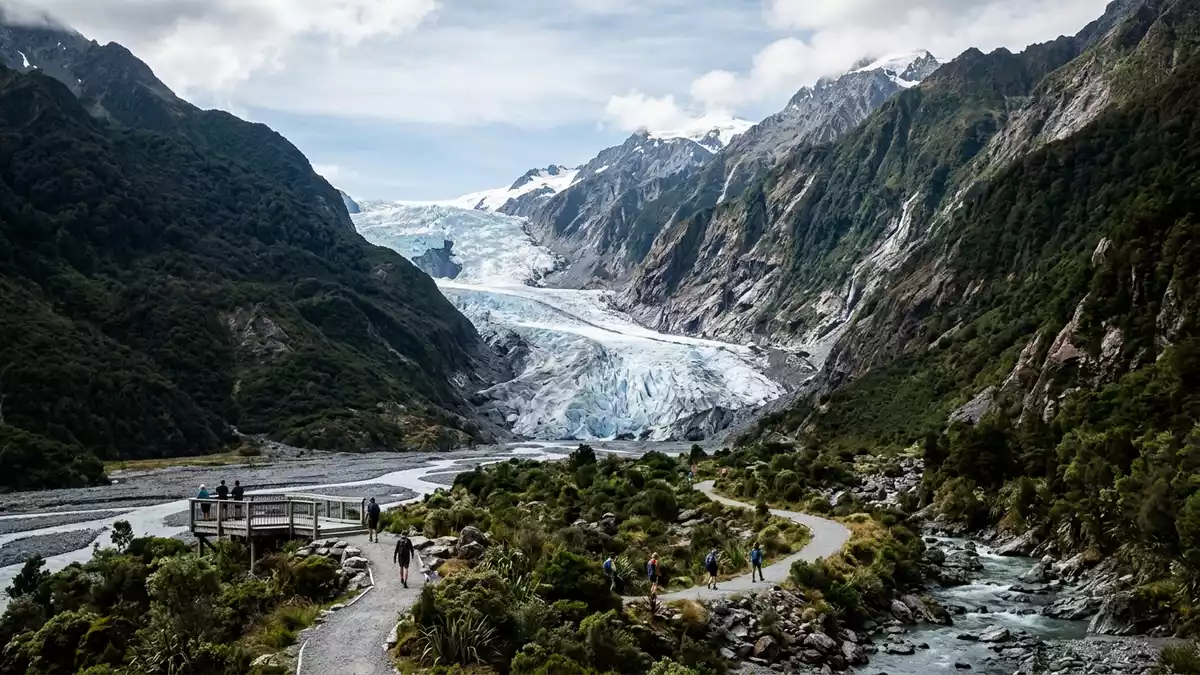
Fox Glacier on New Zealand’s South Island is one of the rare places where a broad river of ice drops from the high Southern Alps into lowland temperate rainforest within walking distance of a small village. The glacier and the settlement share the same name, tying a dynamic landscape of ice, rock and forest to an alpine community at the edge of Westland Tai Poutini National Park.
Ice descending from the Southern Alps
Fox Glacier is a valley glacier flowing down the western flank of the Southern Alps in the West Coast region of New Zealand’s South Island. It lies within Westland Tai Poutini National Park, part of the Te W?hipounamu World Heritage Area recognised for its combination of mountains, glaciers and dense rainforest.Westland Tai Poutini National Park The glacier is officially known in both English and M?ori as Fox Glacier / Te Moeka o Tuawe, “The Bed of Tuawe”, reflecting its significance in local tradition.Fox Glacier / Te Moeka o Tuawe
The glacier is generally described as a temperate maritime glacier, exposed to moist air masses from the Tasman Sea that bring heavy snowfall to its accumulation area. Measurements published for Fox Glacier give a length of around 13 km (8 miles) from its névé in the high Southern Alps down to its lower terminus near the coastal plain.13 km long glacier Over that distance the ice descends roughly 2,600 m (8,500 ft), finishing only a few hundred metres above sea level amid thick forest beside the Fox River valley.descent from the Southern Alps
A glacier beside its village
The name Fox Glacier refers both to the glacier itself and to the small township that serves as its gateway. The village sits on the West Coast’s State Highway 6, in forested foothills backed by steep alpine ridges and surrounded by farmland that shares the narrow coastal strip with river terraces and bush.forest foothills and farmland It functions as the base for guided glacier walks, scenic flights and short hikes to viewpoints, with accommodation and services geared towards visitors drawn to the ice.
Fox Glacier township lies only a short distance inland from the glacier’s lower valley, separated by low hills and the Fox River. The glacier’s terminal face stands a few kilometres from the settlement, making its fractured blue ice and surrounding cliffs accessible on foot along marked tracks in the national park.Fox River valley and terminus This close relationship between a living glacier and a small village gives the place its character: a community of a few hundred people surrounded by rainforest and backed by high snowfields.
Ice, forest and water in one landscape
Approaching Fox Glacier reveals how ice, forest and water share the same narrow valley. The glacier’s tongue squeezes between steep slopes clad in temperate rainforest, its lower reaches terminating above the riverbed where meltwater streams cut across shingle fans and boulders. From viewpoints on the valley floor, the ice appears layered and fractured, with deep crevasses and ridges marking where the glacier flows over bedrock steps.
Above the visible tongue, Fox Glacier is fed by several alpine glaciers and snowfields that gather snow on the crest of the Southern Alps. Named tributaries such as Chancellor Glacier and Victoria Glacier contribute ice to the main flow, which then descends towards the Fox River and the wider Cook River / Weheka catchment before reaching the Tasman Sea.tributary glaciers and river system Nearby, Lake Matheson sits in forest west of the village, offering views of Aoraki / Mount Cook and other peaks reflected in dark water, tying the glacier valley to a wider network of walks and viewpoints in Glacier Country on the West Coast.Fox Glacier and Lake Matheson
Visiting Fox Glacier: what travellers from Western Europe should know
- Fox Glacier is on the West Coast of New Zealand’s South Island, with the township located on State Highway 6 south of Franz Josef Glacier in Westland Tai Poutini National Park.
- Tracks to Fox Glacier viewpoints follow river valleys and forested slopes, with uneven ground, loose rock and sections of steep gradient that demand sturdy footwear and care on wet surfaces.
- Nearby Lake Matheson lies west of Fox Glacier township, reached by a short drive along Cook Flat Road, where a loop track circles the lake through dense forest with occasional mountain views.
- The official language is English and the currency is the New Zealand dollar.
- Entry requirements depend on your nationality; UK travellers can check the FCDO travel advice at gov.uk/foreign-travel-advice, Irish travellers the Department of Foreign Affairs at ireland.ie.
Searching for Fox Glacier on social platforms
These links open searches for Fox Glacier on each platform.
Frequently asked questions about Fox Glacier
Where is Fox Glacier?
Fox Glacier is on the West Coast of New Zealand’s South Island in Westland Tai Poutini National Park, with the village on State Highway 6 near the Fox River.
What should visitors expect when visiting Fox Glacier?
Visitors encounter a steep glacier valley with riverbeds, forest and viewpoints where the lower ice and surrounding cliffs can be seen from marked tracks.
What makes Fox Glacier distinctive among New Zealand’s glaciers?
Fox Glacier is notable for its long descent from the Southern Alps to low elevation near coastal rainforest, and for the close presence of a small gateway village.


