
Fernando de Noronha’s volcanic islands and protected seas
Published on 09/07/2026 at 16:33 | Editorial responsibility: Rafael Müller, Editor-in-Chief AD HOC NEWS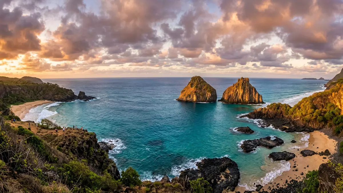
Fernando de Noronha is a Brazilian archipelago in the Atlantic Ocean where volcanic rock, steep green slopes and protected seas form a compact but striking island landscape. Rising from the ocean as part of the state of Pernambuco and designated as a World Heritage site in the early twenty?first century, it combines a small inhabited main island with surrounding protected islets and marine reserves.
Volcanic origins and Atlantic setting
Fernando de Noronha lies off the north?eastern coast of Brazil, forming part of Pernambuco while standing several hundred kilometres out into the Atlantic Ocean. Peaks of a submerged ridge reach the surface here as islands and islets, giving the archipelago its distinctive relief and isolating it from the mainland hinterland.Peaks of the Southern Atlantic submarine ridge The main island is volcanic in origin, rising to an elevation of more than 300 m (around 1,000 ft) above sea level, with slopes that drop towards bays and coves on every side.The main island, rising to 1,089 feet
The archipelago consists of a cluster of islands and islets grouped around the main inhabited island, together covering about 26 km² (10 sq mi) of land.Fernando de Noronha consists of 21 islands and islets The main island itself accounts for most of this area and is the only one with a permanent resident community. Its coastline alternates between sheer cliffs of dark volcanic rock and lower sections where inlets open towards beaches and natural swimming areas, all surrounded by clear Atlantic water.
From strategic outpost to marine national park
The history of Fernando de Noronha is tied to the early sixteenth century, when the archipelago was given in 1504 to the Portuguese merchant Fernando de Noronha after its discovery during Atlantic voyages.Given in 1504 to its Portuguese discoverer, Fernando de Noronha Over later centuries it became a dependency of Pernambuco, reflecting its role as an outlying territory linked administratively to the north?eastern Brazilian coast. Fortifications, simple settlements and infrastructure followed as different powers recognised the strategic importance of a landfall in these waters.
In the twentieth century the Brazilian authorities formalised its status, first as a federal territory and later as the State District of Fernando de Noronha within Pernambuco.Formerly known as the Federal Territory of Fernando de Noronha Environmental protection gained prominence towards the late twentieth century, when most of the surrounding islands and much of the main island were incorporated into a marine national park. Along with Rocas Atoll, the archipelago was then inscribed on the World Heritage List in 2001 under the property name Brazilian Atlantic Islands: Fernando de Noronha and Atol das Rocas Reserves.Brazilian Atlantic Islands: Fernando de Noronha and Atol das Rocas Reserves Protection status limits development across large parts of the islands and emphasises conservation of marine and coastal ecosystems.
Landscapes, beaches and marine life
Nearly 70 percent of the main island and surrounding smaller islands and islets fall within the area of the marine national park, together with adjacent waters down to a depth of about 50 m.Nearly 70% of the main island On land, the protected areas include cliffs, hills and coastal vegetation, while offshore they cover reefs, submarine slopes and habitats used by marine species such as turtles and dolphins. The volcanic origin of the islands is visible in the dark rock faces, stacks and headlands that rise steeply above the sea.
Alongside the cliffs, Fernando de Noronha has beaches and bays where sand, rock and water meet in smaller, enclosed settings. The main island shelters a sequence of beaches facing different exposures, with some open to Atlantic swells and others lying more within inlets. Clear visibility in the surrounding water has made the archipelago well known for diving and snorkelling, supported by the conservation measures that apply within the marine park.The Fernando de Noronha Archipelago, belonging to the state of Pernambuco Offshore, Rocas Atoll adds a reef structure to the protected complex, extending the range of environments included in the World Heritage property.
Visiting Fernando de Noronha: what travellers from Western Europe should know
- Fernando de Noronha lies in the Atlantic Ocean north?east of mainland Brazil, linked administratively to the state of Pernambuco. Scheduled flights connect the main island with Brazilian cities such as Recife and Natal.Access is mainly from Recife and Natal
- The terrain on the main island includes steep slopes, uneven volcanic rock and paths that descend to beaches and viewpoints. Approaches to many coastal areas involve walking sections with gradients and steps.
- Fernando de Noronha forms part of Brazil. The official language is Portuguese and the currency is the Brazilian real.
- Nearby natural features include Rocas Atoll to the west, which together with the archipelago forms the Brazilian Atlantic Islands World Heritage property.
- Entry requirements depend on your nationality; UK travellers can check the FCDO travel advice at gov.uk/foreign-travel-advice, Irish travellers the Department of Foreign Affairs at ireland.ie.
Searching for Fernando de Noronha on social platforms
These links open searches for Fernando de Noronha on each platform.
Frequently asked questions about Fernando de Noronha
Where is Fernando de Noronha located?
Fernando de Noronha is an Atlantic archipelago linked to the Brazilian state of Pernambuco, lying several hundred kilometres off the country’s north?eastern coast.
What should visitors expect on a trip to Fernando de Noronha?
Visitors encounter a volcanic main island with cliffs, beaches and walking paths, surrounded by protected marine areas where ocean conditions and conservation rules shape activities.
What makes Fernando de Noronha distinctive among Brazilian destinations?
Its combination of volcanic topography, isolation from the mainland and extensive marine national park status, together with its World Heritage inscription, sets the archipelago apart within Brazil.


