
Farangi Samarias, the deep limestone corridor of western Kreta
Published on 09/03/2026 at 20:03 | Editorial responsibility: Rafael Müller, Editor-in-Chief AD HOC NEWS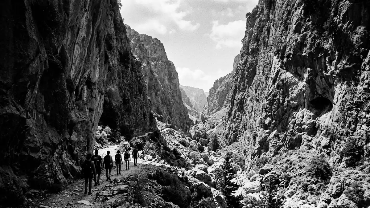
Farangi Samarias, better known in English as the Samaria Gorge, cuts a steep line through the White Mountains of western Kreta, from a high plateau down to the Libyan Sea in Greece. Since 1962 the gorge and its surrounding peaks have formed the Samaria National Park, part of a wider biosphere reserve that protects one of Crete’s most dramatic limestone landscapes.
A limestone chasm from plateau to sea
Farangi Samarias lies in the regional unit of Chania in south-western Crete, within the designated Samaria National Park in the White Mountains range. The protected area covers a mountainous limestone massif recognised as a biosphere reserve under UNESCO’s Man and the Biosphere programme, with the gorge as its defining featurein a mountainous limestone area. The gorge itself runs between the Omalos plateau in the north and the coastal village of Agia Roumeli on the Libyan Sea, forming a continuous descent from upland pasture to open waterstarting at an altitude of 1,250 m and ending at the sea in Agia Roumeli.
The walking route that follows the gorge covers roughly 16 km (10 miles) from the trailhead at Xyloskalo above Omalos down to the pebble beach at Agia Roumeli, including the gently sloping track near the coastthe entire route to the beach of Agia Roumeli is 16km. Over this length the path drops more than 1,000 m (3,281 ft), turning from constructed steps at the upper entrance into a stony riverbed flanked by high rock walls. The gorge has become one of Crete’s most characteristic long-distance day hikes, combining extended downhill walking with the gradual transition from mountain climate to coastal heat.
Narrow passages, high walls and a vanished village
Much of Farangi Samarias follows the line of a seasonal river, so the path alternates between sections on compacted earth and stretches that cross the stony channel from bank to bank. In places the enclosing cliffs rise several hundred metres above the riverbed, creating a deep corridor of pale and grey limestone with scattered pines and shrubs on ledges and slopesthe gorge reaches 13 km in length within a wider 18 km route. A highlight of the lower section is the pair of constricted cliffs known in Greek as the “Gates”, where the walls stand close on either side of the riverbed and accentuate the sense of depth. Elsewhere the gorge opens into wider basins where scree fans, terraces and clusters of trees soften the scale of the rock faces.
Roughly midway through the protected area the path passes the site of the former village of Samaria, abandoned when the gorge became a national park in 1962the Samaria Gorge has been a National Park of Greece since 1962. Stone houses, a small church and cultivated clearings sit close to the river, giving a sense of how people once lived within this confined valley. From here the path continues downstream through forested stretches and between boulders, before eventually emerging into the wider lower gorge and the coastal plain behind Agia Roumeli.
National park protections and natural life
Samaria National Park was established in 1962 to protect the gorge and surrounding White Mountains, and it later became part of the international network of biosphere reserves. The protected zone includes not only the main gorge but also side ravines, peaks and upland plateaus within the same geological unitSamaria (White Mountains) National Park is a multi-designated area. It forms the core of a larger Natura 2000 landscape, recognising the ecological value of habitats that range from high-altitude rock slopes to riparian woodland along the riverbed.
The gorge environment supports a variety of Cretan plant species adapted to steep limestone terrain, including trees clinging to rock faces and shrubs rooted in narrow ledges. The park is also known as habitat for wild goats native to Crete and for birds of prey that use the thermal currents along the cliffs. Management by the Greek authorities limits access to a defined season and monitors the walking route, reflecting the status of Samaria National Park as part of the World Network of Biosphere Reservesthe National Park of Samaria is part of the UNESCO World Network of Biosphere Reserves.
Visiting Farangi Samarias: what travellers from Western Europe should know
- Farangi Samarias is in south-western Crete, in the regional unit of Chania, with the northern entrance at Xyloskalo above the Omalos plateau and the exit at Agia Roumeli on the Libyan Sea.
- The classic route through the gorge involves sustained downhill walking on rocky and sometimes uneven ground, including many steps at the start and long sections on a stony riverbed.
- The full crossing follows the gorge for several hours, so sturdy footwear and a realistic sense of personal fitness are important considerations for anyone planning the walk.
- The official language is Greek and the currency is the euro.
Searching for Farangi Samarias on social platforms
These links open searches for Farangi Samarias on each platform.
Frequently asked questions about Farangi Samarias
Where is Farangi Samarias?
Farangi Samarias is in the south-west of Crete in Greece, in the White Mountains of the Chania regional unit, between the Omalos plateau and Agia Roumeli on the Libyan Sea.
What should visitors expect on the walk?
The walk through Farangi Samarias follows a long downhill route on stepped paths and stony riverbed, surrounded by high limestone cliffs and patches of woodland.
What makes Farangi Samarias distinctive among Cretan landscapes?
Farangi Samarias combines a deep limestone gorge, a continuous descent from upland plateau to sea and a protected national park setting within a recognised biosphere reserve.


