
El Yunque National Forest rises through Puerto Rico’s cloud forest
Published on 09/22/2026 at 14:40 | Editorial responsibility: Rafael Müller, Editor-in-Chief AD HOC NEWS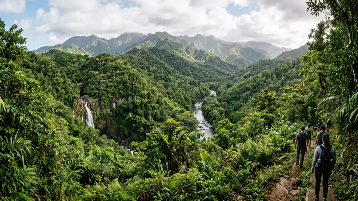
El Yunque National Forest rises above Rio Grande on the slopes of Puerto Rico’s Sierra de Luquillo. Its visible character is a mountain rainforest layered from lower tabonuco trees through palms to cloud forest, with rivers and waterfalls threaded between the ridges.
El Yunque National Forest on the slopes of the Sierra de Luquillo
The forest lies in north-eastern Puerto Rico, inland from the Atlantic coast and across a mountainous landscape connected with Rio Grande and neighbouring municipalities. The main road into its recreation corridor is PR-191, which climbs from Rio Grande towards the forested interior.
Nearly 29,000 acres of protected land cover steep ridges, streams and valleys. Elevation rises from low foothills towards El Toro, the highest point of the forest, at about 1,074 m (3,524 ft). The terrain changes visibly with height, from broadleaf forest to sierra palm stands and vegetation associated with the ridges.
The forest belongs to the Luquillo Experimental Forest and became a UNESCO Biosphere Reserve in 1976. Its protected landscape combines tropical ecology with a long record of public forest management. the 1976 biosphere designation remains part of El Yunque’s formal identity.
Four forest zones, rivers and waterfalls
El Yunque contains four recognisable forest types: tabonuco forest, sierra palm forest, colorado forest and cloud forest. The names describe different plant communities within the mountain environment, rather than separate parks or enclosed gardens.
Tabonuco trees occupy lower montane areas, while sierra palms appear on steeper slopes. Palo colorado forest occupies wetter upland ground, and cloud forest lies along the higher ridges. Mist, dense vegetation and exposed mountain contours are recurring features of the upper landscape.
Water is central to the forest’s visible geography. The Río Mameyes, Río de la Mina and Río Icacos are federally designated Wild and Scenic Rivers. Their channels run through ravines and forested valleys, while smaller streams feed waterfalls and natural pools.
La Mina Falls drops more than 10 m (35 ft) through large rocks into a pool along the La Mina River. The La Mina Trail follows the river through tropical vegetation. La Mina Falls and its river form one of the forest’s clearest encounters between water and mountain terrain.
A protected forest with Taíno and Spanish names
Spanish King Alfonso XII set aside part of the Luquillo Mountains as a forest reserve in 1876. The protected landscape entered the United States National Forest System after the transfer of Puerto Rico in 1898.
The reserve became the Luquillo Forest Reserve in 1903. It was renamed the Luquillo National Forest in 1907, became the Caribbean National Forest in the twentieth century, and received the name El Yunque National Forest in 2007.
The name El Yunque is linked with the Taíno word Yuké, associated with the white, cloud-covered mountains. The Spanish phrase El Yunque refers to an anvil. Both names connect the forest with the shape and clouded appearance of the Luquillo range.
Research has accompanied conservation in the forest for decades. The Luquillo Experimental Forest supports study of tropical trees, streams and soils, while the national forest designation protects a landscape used for recreation, scientific work and water resources. El Yunque’s changing names trace its movement through Spanish, American and Puerto Rican history.
Visiting El Yunque National Forest: what travellers from Western Europe should know
- El Yunque National Forest is reached from Rio Grande by PR-191, the principal mountain road into the northern recreation corridor. From San Juan, the route uses PR-26, PR-66, PR-3 and PR-191.
- The landscape includes steep mountain roads, rocky trails, stream crossings and exposed elevation gain. Routes towards El Yunque Peak pass through several forest communities as the altitude increases.
- Yokahú Tower rises about 21 m (69 ft) above the forest. Its outlook includes the forest zones, the coastline and the upper Mameyes Valley.
- Spanish and English are official languages in Puerto Rico, and the currency is the United States dollar.
Searching for El Yunque National Forest on social platforms
These links open searches for El Yunque National Forest on each platform.
Frequently asked questions about El Yunque National Forest
Where is El Yunque National Forest?
El Yunque National Forest is in north-eastern Puerto Rico, on the Sierra de Luquillo above Rio Grande. The forest extends across several municipalities.
What can visitors expect in the forest?
Visitors encounter mountain roads, tropical forest, rivers, waterfalls, viewpoints and trails with changing vegetation. The terrain includes steep slopes, wet ground and rocky stream valleys.
What makes El Yunque distinctive?
Its forest zones rise from lower tabonuco woodland to sierra palm and cloud forest. Its protected history reaches back to 1876, and its rivers connect the rainforest with Puerto Rico’s wider water landscape.


