
Death Valley National Park’s extremes around Furnace Creek
Published on 09/14/2026 at 10:13 | Editorial responsibility: Rafael Müller, Editor-in-Chief AD HOC NEWS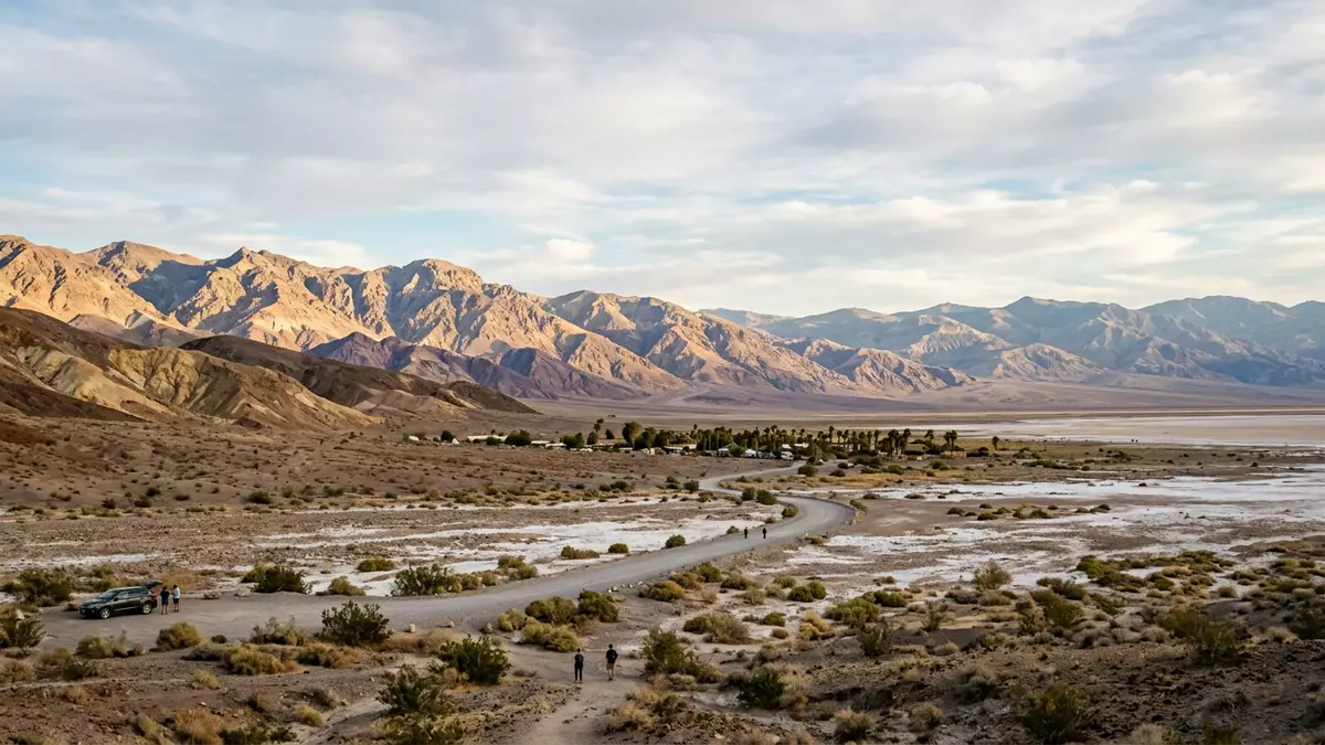
Death Valley National Park in eastern California stretches around Furnace Creek in a desert landscape where some of North America’s most extreme elevations and temperatures sit within a single protected area. The park forms part of the Mojave and Great Basin deserts and has been managed as a unit of the United States National Park Service since the twentieth century.
From Badwater Basin to Telescope Peak
The core contrast that shapes any visit to Death Valley National Park is the relationship between its low salt flats and the mountain ridges that rise above them. Badwater Basin, south of Furnace Creek, lies more than 80 m (over 260 ft) below sea level, forming a bright crust of salt where an ancient lake has left its minerals behind.Badwater Basin lies below sea level This depression stands against the surrounding alluvial fans and gravel slopes that lead the eye towards the darker mountain ranges.
West of the valley floor, the Panamint Range carries Telescope Peak, which rises to about 3,368 m (11,049 ft) above sea level and marks the highest point in the park.Telescope Peak is the tallest mountain Between Telescope Peak and Badwater Basin, the relief exceeds 3,400 m (over 11,000 ft) in a relatively short horizontal distance, giving the landscape a pronounced vertical scale.The park’s highest peak rises over 3,300 m Snow can linger on the upper slopes of the Panamint Range in some months while the valley floor remains dry and pale below.
Furnace Creek: an oasis and gateway
Furnace Creek, in Inyo County, California, serves as the administrative and visitor hub for Death Valley National Park, with the main visitor centre, museum and park headquarters clustered near its palm groves.The visitor centre and park headquarters stand at Furnace Creek The settlement occupies ground below sea level and is surrounded by irrigated greenery that stands out against the surrounding desert.
The date palm avenues and lawns form part of a resort complex historically known as Furnace Creek Resort, established in the 1920s as a way to provide accommodation, shade and water in the middle of the desert.Furnace Creek developed as an oasis resort from 1927 Travertine Springs feed artificial pools and irrigation channels, sustaining groves of Deglet Noor date palms and ornamental shrubs around the buildings. These cultivated areas contrast with the bare hills and salt-encrusted flats that extend just beyond the irrigated zone.
Heat, light and desert geology
Death Valley gained international attention in 1913 when a temperature of 57 °C (134 °F) was recorded at what was then known as Furnace Creek Ranch, a figure still cited as one of the highest air temperatures measured on Earth.A temperature of 57 °C was recorded at Furnace Creek in 1913 The valley floor presents broad salt pans, gravel plains and bare rock, with little vegetation away from springs and alluvial fans.
Geologically, the park spans parts of the Amargosa Range to the east and the Panamint Range to the west, with sedimentary and volcanic rocks folded and faulted into ridges and basins.Death Valley National Park covers a large desert basin and surrounding ranges Viewpoints such as Dante’s View look across to the Panamint Mountains, with Telescope Peak visible against the skyline.Dante’s View faces the Panamint Mountains and Telescope Peak At night, the low level of artificial lighting has led to international recognition for dark skies, and stars can appear in dense bands over the desert.
Visiting Death Valley National Park: what travellers from Western Europe should know
- Death Valley National Park lies in eastern California, with Furnace Creek roughly north of Badwater Basin; it is reached by road, with routes crossing the Amargosa Desert from Nevada and California towns.
- The terrain around Furnace Creek combines below-sea-level flats and surrounding mountains, so visits can involve driving on exposed desert highways and walking on uneven, rocky ground near viewpoints.
- Temperatures on the valley floor can rise well above 40 °C in hotter months, while higher elevations near the Panamint Range and Telescope Peak remain markedly cooler in the same season.
- The official language is English and the currency is the United States dollar.
- Entry requirements depend on your nationality; UK travellers can check the FCDO travel advice at gov.uk/foreign-travel-advice, Irish travellers the Department of Foreign Affairs at ireland.ie.
Searching for Death Valley National Park on social platforms
These links open searches for Death Valley National Park on each platform.
Frequently asked questions about Death Valley National Park
Where is Death Valley National Park?
Death Valley National Park lies in eastern California and extends into Nevada, with its main visitor hub at Furnace Creek in Inyo County.
What should visitors expect on a first visit?
Visitors encounter a desert basin with salt flats, gravel plains and surrounding mountain ranges, along with a cluster of facilities and greenery around Furnace Creek.
What makes Death Valley National Park distinctive?
The combination of extreme heat records at Furnace Creek, the low elevation of Badwater Basin and the height of Telescope Peak gives the park a striking range of desert environments.


