
Death Valley National Park and the depths of Furnace Creek
Published on 08/19/2026 at 22:27 | Editorial responsibility: Rafael Müller, Editor-in-Chief AD HOC NEWS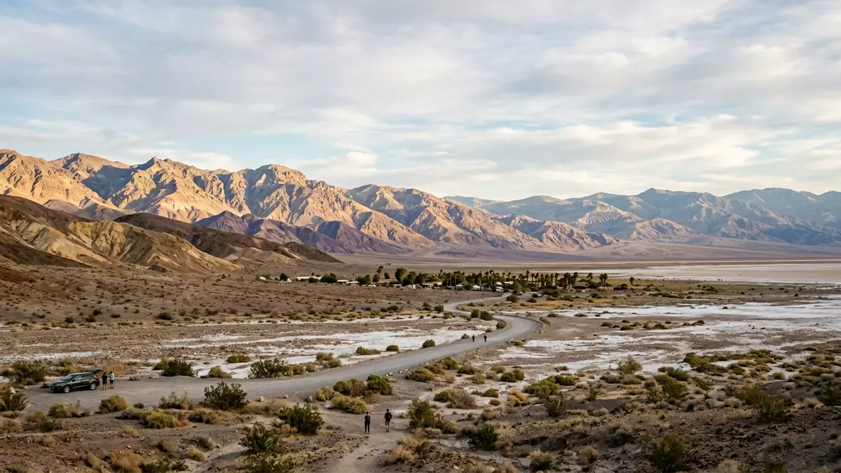
Death Valley National Park in California brings together a basin below sea level, bare mountain ranges and tilted badlands in a single vast desert landscape. At Furnace Creek, the park’s main hub, the ground lies below sea level and the desert floor stretches out towards salt flats and distant summits of the Panamint Mountains.
A desert basin below sea level
Death Valley National Park straddles part of the Mojave Desert in eastern California and protects a long north–south trench edged by steep mountain ranges. The principal developed area at Furnace Creek sits in Inyo County, with the settlement recognised as a census-designated place where the land lies around 58 m (190 ft) below sea level.Furnace Creek, California The valley floor runs down towards Badwater Basin, the lowest point in North America at about 86 m (282 ft) below sea level, where salt has crusted into a broad white pan.Badwater Basin, 282 feet below sea level
Across the valley, the Panamint Mountains rise sharply from the desert floor, culminating in Telescope Peak at 3,368 m (11,049 ft) above sea level.Telescope Peak, the highest peak The close pairing of this summit with the low basin creates an elevation contrast of more than 3,300 m (over 11,000 ft) within a relatively short horizontal distance. Standing at Furnace Creek, the view takes in the broad floor of Death Valley, distant alluvial fans spreading from side canyons and pale belts of salt that mark former lake beds.
Furnace Creek as the park’s human centre
Furnace Creek has developed as the administrative and visitor focus of Death Valley National Park, with the park headquarters and a visitor centre grouped near the desert floor.The visitor center, museum, and headquarters The surrounding settlement holds a small permanent population measured in the low hundreds, a figure that reflects its role as a service point rather than a large town. A spring-fed water source has long been harnessed here, turning part of the desert floor into irrigated ground and enabling early ranch developments that were later adapted into resort facilities.Pacific Coast Borax turned the crew quarters of its Furnace Creek Ranch into a resort
The Furnace Creek area also preserves traces of industrial history from the late nineteenth century. Nearby Harmony Borax Works records how borax extraction and processing drew workers into Death Valley in the late 1800s, leaving low ruins and the heavy frames of wagons that hauled refined borax out of the basin.Harmony Borax Works was instrumental in drawing people to Death Valley These remains sit on a short paved path, where the outlines of processing structures and the alignment of trackways can still be traced against the desert gravel.
Salt flats, badlands and dunes around Furnace Creek
From Furnace Creek, three of Death Valley National Park’s most recognisable landscapes lie along a rough triangle: the salt flats of Badwater Basin, the sculpted badlands of Zabriskie Point and the dune field at Mesquite Flat. Badwater Basin spreads south along a broad valley, its surface patterned by salt-encrusted ground that reflects the intense light.Badwater Basin, the lowest point in North America North-west of Furnace Creek, the Mesquite Flat Sand Dunes rise from the valley floor near Stovepipe Wells, forming an open field of dunes shaped by winds crossing the basin.Mesquite Flat Sand Dunes
To the east, the badlands around Zabriskie Point reveal multi-coloured hills carved from sediments of an ancient lake, with narrow ridges and eroded gullies dropping away from the viewpoint.Zabriskie Point, badlands views Above the basin, Dante’s View stands on the crest of the Black Mountains at an elevation of about 1,670 m (5,475 ft), giving a high vantage point over Badwater Basin and across to the Panamint Mountains.Dante's View offers panoramic views These four named landscapes together frame the Furnace Creek area, showing how salt flats, dune fields, badlands and mountain summits all lie within a single protected desert basin.
Visiting Death Valley National Park: what travellers from Western Europe should know
- Death Valley National Park lies in eastern California, with Furnace Creek reached by road from the direction of Pahrump in Nevada or from the California side on Highway 190, which crosses the valley floor near the main visitor area.entered the park on 190 via Pahrump
- The terrain around Furnace Creek and Badwater Basin is desert basin floor, with hard salt and gravel underfoot on the flats and loose sand in the dune fields; higher viewpoints such as Zabriskie Point and Dante’s View are reached by paved roads leading to short walks on inclined paths.Zabriskie Point provides visitors with panoramic views
- The official language is English and the currency is the United States dollar.
- Entry requirements depend on your nationality; UK travellers can check the FCDO travel advice at gov.uk/foreign-travel-advice, Irish travellers the Department of Foreign Affairs at ireland.ie.
Searching for Death Valley National Park on social platforms
These links open searches for Death Valley National Park on each platform.
Frequently asked questions about Death Valley National Park
Where is Death Valley National Park in relation to Furnace Creek?
Death Valley National Park stretches across eastern California, with Furnace Creek located on the valley floor as the park’s main administrative and visitor hub.
What should visitors expect when they arrive at Furnace Creek?
Visitors encounter a desert basin below sea level with a visitor centre, traces of borax industry and road access to salt flats, badlands viewpoints and nearby dunes.
What makes the Furnace Creek area distinctive within the park?
Furnace Creek combines the park headquarters, irrigated desert oasis, industrial history at Harmony Borax Works and quick access to Badwater Basin, Zabriskie Point and Mesquite Flat Sand Dunes.


