
Danakil Depression: salt, rift and fire near Dallol
Published on 08/28/2026 at 11:22 | Editorial responsibility: Rafael Müller, Editor-in-Chief AD HOC NEWS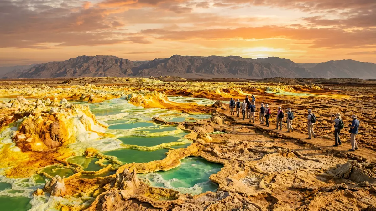
The Danakil Depression in Ethiopia’s Afar Region is a geological basin where salt plains, active rifting and geothermal fields come together in an exceptionally harsh landscape. Set near the hydrothermal area of Dallol, it lies far below sea level in the northern part of the Afar Triangle and forms one of Africa’s lowest arid plains.
Afar rift basin below sea level
The Danakil Depression forms the northern section of the Afar Rift, a tectonic junction where the Nubian, Somalian and Arabian plates meet alongside the Danakil microplate. The basin runs roughly north–south for around 200 km and reaches depths of more than 100 m below sea level in places, creating one of the lowest subaerial landscapes on the African continent.north–south basin Its floor is largely an arid plain bounded by the Ethiopian Plateau to the west and the Danakil Alps to the east, with Lake Afrera towards the south, giving the depression a broadly triangular outline.triangular area between plateau and Alps
Across the depression, much of the surface is covered by salt flats and evaporite deposits, with basalt flows, shield volcanoes and cinder cones emerging where magma reached the surface.salt flats and basalt flows The area lies in an extremely arid climate, and repeated flooding by seawater and later evaporation have left thick sequences of halite, gypsum and other salts in the basin. In the northern sector, these evaporites form a broad salt pan around Dallol that marks the deepest part of the depression.
Salt plains and the Dallol dome
Near Dallol, the Danakil Depression is dominated by a wide salt pan known as the Dallol salt flat, a halite-floored basin that occupies the central part of the northern depression. Geological studies describe a thick succession of Quaternary evaporites beneath this flat, with normal faults defining the edges of the depocentre and shaping the basin where salt has accumulated.evaporite depocentre near Dallol The surrounding plain lies roughly 100 m below sea level, with some points near nearby lakes and the Dallol area reaching more than 120 m below sea level.lowland plain below sea level
At the heart of this salt pan rises the Dallol dome, an uplifted halo?volcanic structure composed largely of bedded halite and anhydrite layers. The dome stands several tens of metres above the surrounding flat and forms an elliptical mound aligned roughly east–west, where geothermal deposits partially cover the salt strata.uplifted salt dome Geologically, this structure is linked to the intrusion of basaltic magma into Miocene marine evaporites in the Danakil Depression, producing a salt dome that hosts a terrestrial hydrothermal system.hydrothermal system in salt dome
Geothermal colours and extreme conditions
The geothermal area around Dallol is characterised by pools, mounds and terraces where hot, mineral?rich fluids reach the surface through the salt deposits. These features build up layers of salt and other minerals, creating vivid yellow, green and orange surfaces where iron, sulphur and other elements precipitate onto the salt crusts.geothermal deposits on salt dome The environment combines very high salinity, hydrothermal fluids and acidic waters, making it a polyextreme setting that has attracted scientific interest in fields ranging from geology to microbiology.polyextreme geothermal environment
Beyond the immediate dome, the floor of the Danakil Depression carries several salt lakes and thick salt formations connected to the wider evaporitic history of the Afar Rift.salt lakes and thick formations Erta Ale, a basaltic volcano with a lava lake, rises towards the southern part of the depression, linking the geothermal field at Dallol with the broader volcanic chain that follows the rift. Together, these sites present an exposed view of continental breakup, where young oceanic crust forms within a desert basin lined by salt.
Visiting Danakil Depression: what travellers from Western Europe should know
- The Danakil Depression lies in the Afar Region of north?eastern Ethiopia, close to the border with Eritrea and within reach from the town of Mekelle by road across desert terrain.
- The area around Dallol consists of wide salt plains and uneven crust, with sections of brittle salt surface and mineral mounds that require sure footing on rough ground.
- Temperatures in the Danakil Depression can reach high values in the shade, and the combination of heat, sun exposure and arid air calls for careful preparation for any journey into the basin.
- English is widely used in scientific descriptions of the area, but the official language of Ethiopia is Amharic and the currency is the Ethiopian birr.
- Entry requirements depend on your nationality; UK travellers can check the FCDO travel advice at gov.uk/foreign-travel-advice, Irish travellers the Department of Foreign Affairs at ireland.ie.
Searching for Danakil Depression on social platforms
These links open searches for Danakil Depression on each platform.
Frequently asked questions about Danakil Depression
Where is the Danakil Depression in relation to Dallol?
The Danakil Depression lies in the northern Afar Region of Ethiopia, with the Dallol geothermal area situated in its northern sector on the salt plain.
What kind of landscape can travellers expect?
The depression combines wide salt flats, salt lakes, uplifted salt structures and basaltic volcanic features, with geothermal pools and mineral terraces around Dallol.
What makes the Danakil Depression distinctive among rift valleys?
It is a deep rift basin below sea level where thick evaporite sequences, salt domes and active volcanism are exposed together, illustrating continental rifting in an arid setting.


