

Crater Lake National Park and the deep blue caldera of Mount Mazama
Published on 08/26/2026 at 17:42 | Editorial responsibility: Rafael Müller, Editor-in-Chief AD HOC NEWS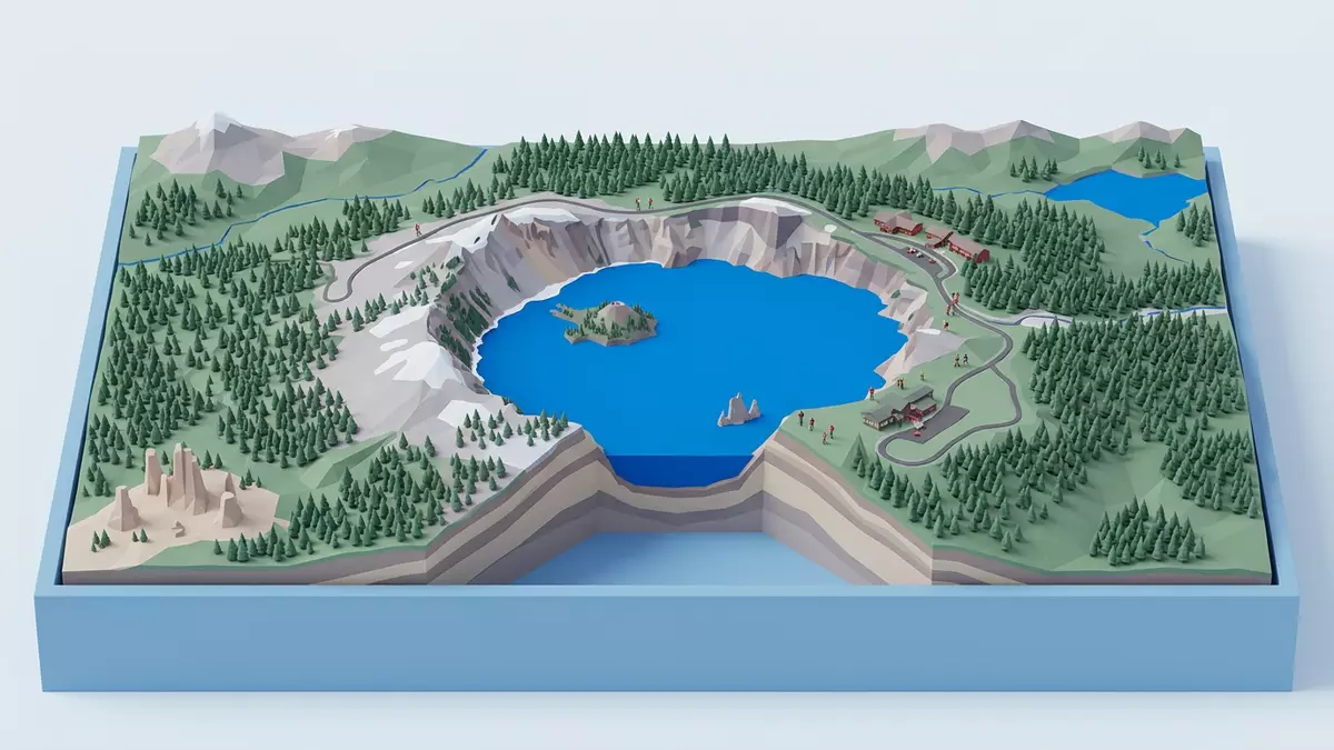
Crater Lake National Park in southern Oregon gathers the deep blue waters of Crater Lake inside the vast volcanic basin of Mount Mazama, a landscape shaped by eruption and collapse thousands of years ago. Established on 22 May 1902 as Oregon’s only national park, it is defined by the contrast between a near-perfect bowl of water and the steep ring of cliffs that encircle it.Crater Lake is located in Southern Oregon
A caldera filled with extraordinary depth and colour
Crater Lake lies inside a caldera formed when the stratovolcano Mount Mazama collapsed about 7,700 years ago, leaving a basin that later filled with rain and snowmelt.Mount Mazama collapsed 7,700 years agoThe lake averages more than 5 miles (about 8 km) in diameter and sits within rock walls that rise to about 600 m above the water surface.steep rock walls that rise up to 2000 feet
The water reaches a maximum depth measured at about 592 m, making Crater Lake the deepest lake in the United States and among the deepest worldwide.Crater Lake is the deepest lake in the United StatesThere are no inflowing rivers or outflowing streams, so the lake is fed entirely by precipitation and snowmelt, and its level is balanced by evaporation and seepage through the caldera walls.there are no inlets or outlets to the lakeThe result is exceptionally clear water with measured transparency of around 31 m and a distinctive deep blue colour that reflects its purity.rich blue color and extreme clarity
Rim Drive, viewpoints and the shape of the crater
The national park encircles Crater Lake with high ground that offers views into the basin from many angles, giving visitors a sense of the caldera’s scale and symmetry.The national park encompasses 183,224 acresThe main road follows the rim for dozens of kilometres, tracing cliffs, pull-outs and trailheads along the crater’s edge and revealing how the lake surface sits far below the surrounding plateau.
Along this rim, the caldera walls expose layers of volcanic rock that record the construction and destruction of Mount Mazama, from older lava flows to younger deposits from the climactic eruption.Crater Lake lies inside a caldera, or volcanic basinThe lake surface stands at about 1,883 m above sea level, while the highest point within the park, Mount Scott, rises to about 2,722 m, giving the rim a consistent sense of height around the basin.Mount Scott, highest point in parkFrom various viewpoints the water appears as a continuous disc punctuated by the silhouettes of Wizard Island and smaller volcanic features that emphasise the basin’s volcanic origin.
Wizard Island, volcanic history and high Cascades weather
Rising from the western side of Crater Lake, Wizard Island is a cinder cone built after the main collapse of Mount Mazama, its slopes descending into the lake and its summit forming a smaller crater within the larger basin.Crater Lake is a volcanic crater lakeThis cone, together with other submerged volcanic features, shows that volcanic activity continued after the caldera formed, gradually constructing new landforms inside the lake.
Crater Lake National Park lies on the crest of the Cascade Range in Klamath County, part of a chain of volcanoes stretching from northern California towards British Columbia.on the crest of the Cascade Mountain rangeThe surrounding high country sits at elevations of around 2,000 m and receives substantial winter snowfall measured in double-digit metres, so snow can linger around the rim while the lake surface remains liquid due to the heat stored in its great volume.Snowfall, yearly average: 44 feet
Visiting Crater Lake National Park: what travellers from Western Europe should know
- Crater Lake National Park lies in southern Oregon in the United States, with the caldera located roughly east of the Pacific coast and inland from the Cascade Range.
- The rim area stands at high elevation around 2,000 m, so paths and viewpoints involve gradients, and some trails descend steeply towards the lake shore.
- Forests of conifer trees surround the caldera, and weather in the high country can change quickly, with snow banks and wet ground persisting around the rim in colder seasons.
- The official language is English and the currency is the United States dollar.
- Entry requirements depend on your nationality; UK travellers can check the FCDO travel advice at gov.uk/foreign-travel-advice, Irish travellers the Department of Foreign Affairs at ireland.ie.
Searching for Crater Lake National Park on social platforms
These links open searches for Crater Lake National Park on each platform.
Frequently asked questions about Crater Lake National Park
Where is Crater Lake National Park?
Crater Lake National Park is in Klamath County in southern Oregon, on the crest of the Cascade Range in the western United States.
What should visitors expect on a visit?
Visitors encounter a high-elevation volcanic landscape, with a deep blue lake enclosed by cliffs, forested slopes, and a rim road that reveals the caldera from many viewpoints.
What makes Crater Lake National Park distinctive?
The park centres on Crater Lake, a caldera lake formed by the collapse of Mount Mazama, whose depth, clarity and surrounding cliffs create a concentration of volcanic scenery in one basin.


