
Crater Lake National Park and the collapsed volcano that holds it
Published on 09/14/2026 at 07:27 | Editorial responsibility: Rafael Müller, Editor-in-Chief AD HOC NEWS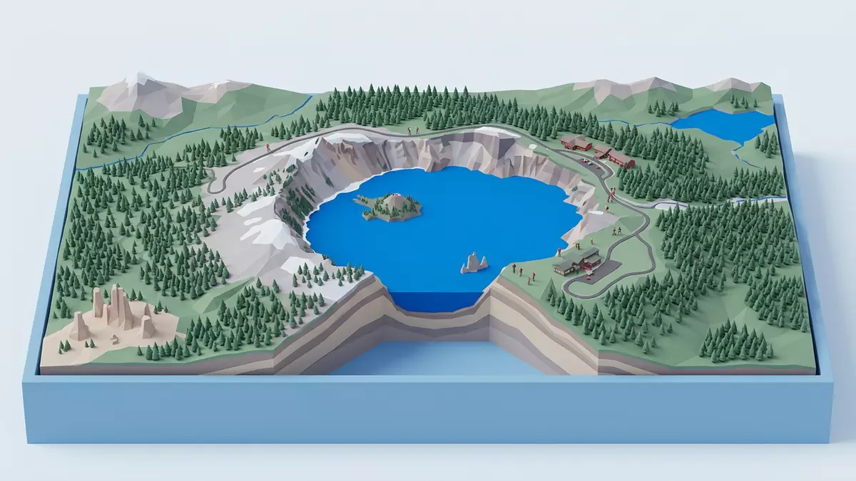
Crater Lake National Park in southern Oregon centres on Crater Lake, a deep basin of extraordinarily clear water held within the collapsed summit of Mount Mazama, an ancient Cascade volcano. The lake, the encircling cliffs and the forested flanks together form a compact landscape where volcanic history is written in visible layers of rock, shoreline and ridge.
A lake inside a collapsed mountain
Crater Lake occupies a volcanic depression known as a caldera that formed when Mount Mazama, a volcano of the Cascade Range, erupted and collapsed. The caldera developed during a climactic eruption of Mount Mazama about 7,700 years ago, an event that expelled large volumes of magma and left a deep, steep-sided basin in place of the former summit.climactic eruption 7,700 years ago The volcano itself had grown over roughly 400,000 years through overlapping lava flows, reaching an elevation of about 3,700 m (12,000 ft) before its sudden change to a hollowed-out form.3,700 m volcano known as Mount Mazama
The caldera partly infilled with Crater Lake as rain and snow accumulated in the basin over many centuries, a process that continued once post-eruption volcanic activity had sealed the floor. The caldera reaches a depth of around 1,200 m (3,900 ft) from rim to floor, giving the lake a considerable volume of water held entirely within the mountain’s former core.1,200 m deep caldera Crater Lake has no significant inflowing streams, so its clarity reflects the limited sediment supply and the balance between precipitation, evaporation and seepage.
Depth, colour and volcanic features
Crater Lake is among the deepest lakes in the United States, with modern surveys measuring a maximum depth of 592 m (1,943 ft) below the surface.depth of 1,943 feet The depth and enclosed setting give the water a rich blue colour when viewed from the rim, contrasting with the pale volcanic slopes above the shoreline. The lake surface lies far below the rim road, so many viewpoints look down across an extensive expanse of open water bordered by cliffs.
Within the lake several younger volcanic structures rise from the caldera floor, the most prominent being Wizard Island, a cinder cone that forms a small island near the western shore.Wizard Island cinder cone Other submerged features include Merriam Cone and a central platform, all built by postcaldera eruptions that followed the main collapse of Mount Mazama. The lake bed also carries fans of landslide debris from the rim and layers of sediment formed by material washed from the caldera walls.
Rim landscapes and the road around the lake
The caldera rim of Crater Lake National Park forms an irregular ring of high ground, with viewpoints, trailheads and forested slopes above precipitous inner walls. A paved Rim Drive follows this high ground around much of the lake, giving access to overlooks that reveal different angles on the water and the surrounding volcanic forms.Rim Drive circles the lake From these stops, visitors can see individual peaks on the rim, exposed layers of lava and ash, and the way forest returns on gentler slopes away from the cliffs.
Trails from the rim descend or climb to specific features, including paths to Garfield Peak and Mount Scott that reach summits overlooking the caldera.trailheads along the rim Another trail leads down to the lakeshore, where the contact between the deep water and the volcanic rock can be seen at close range. Away from the lake, meadows and streams on the flanks of the former volcano give a softer counterpoint to the stark inner basin.
Visiting Crater Lake National Park: what travellers from Western Europe should know
- Crater Lake National Park lies in the Cascade Range of southern Oregon in the United States, with the lake occupying the caldera of Mount Mazama above surrounding forests.
- Terrain within the park alternates between steep caldera walls, high viewpoints on the rim and more moderate gradients on outer slopes, with some trails involving sustained climbs or descents.
- Summits such as Mount Scott and Garfield Peak stand at higher elevations above the lake, so weather conditions and temperatures can vary markedly between the rim and low-lying areas.
- The official language is English and the currency is the United States dollar.
- Entry requirements depend on your nationality; UK travellers can check the FCDO travel advice at gov.uk/foreign-travel-advice, Irish travellers the Department of Foreign Affairs at ireland.ie.
Searching for Crater Lake National Park on social platforms
These links open searches for Crater Lake National Park on each platform.
Frequently asked questions about Crater Lake National Park
Where is Crater Lake National Park?
Crater Lake National Park is in southern Oregon, United States, in the Cascade Range, enclosing the caldera and flanks of Mount Mazama around Crater Lake.
What can visitors expect on a visit?
Visitors encounter a deep volcanic lake surrounded by high caldera walls, viewpoints along a rim road, forested outer slopes and trails that reach summits and lakeshore.
What makes Crater Lake National Park distinctive?
The park is distinctive for its lake occupying a collapsed volcano summit, its considerable depth, its clear water and the presence of volcanic features such as Wizard Island within the basin.


