
Chichen Itza’s stone geometry in the Yucatán plain
Published on 08/30/2026 at 10:05 | Editorial responsibility: Rafael Müller, Editor-in-Chief AD HOC NEWS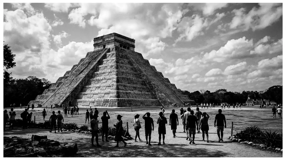
On the limestone plain east of Valladolid in Mexico, the ruined city of Chichen Itza rises as a geometry of stone against level ground. Here a Maya urban centre from the Late Classic and Early Postclassic periods spreads over several square kilometres, with the step-pyramid known as El Castillo set at the heart of plazas, ball courts and columned halls that still mark the layout of a pre-Columbian metropolis.ruined ancient Maya city
El Castillo: a pyramid of counted steps
El Castillo, also called the Temple of Kukulcan, dominates the central plaza as a stepped limestone pyramid with a square base and a summit temple.Temple of Kukulcan Built between the eighth and twelfth centuries CE, it stands about 30 m (98 ft) tall including the temple, with the main pyramid body rising roughly 24 m (79 ft) to the platform below the sanctuary.30 m including the temple Each of its four sides carries stairways framed by balustrades, leading up through nine terraces whose proportions give the structure a rigorous, almost modular rhythm when seen from the base.
The stairways are counted as part of a wider scheme. Combined across the four sides and the top platform, they number 365 steps, matching the days of the solar year.365 steps for the solar year The temple at the summit served the feathered serpent deity Kukulcan, and the pyramid’s edges and platforms form a backdrop for shadow effects that align with the equinoxes, when light along the staircase can trace a segmented serpent body. Even without the equinox spectacle, the consistent rise of terraces and the clear profile of the summit room make El Castillo a study in how astronomy, ritual and monumental architecture were bound together in Maya design.
Cenotes, plazas and the wider city
Around El Castillo, Chichen Itza extends as an organised ensemble of ceremonial spaces, residential platforms and water sources anchored in the porous Yucatán bedrock.occupying an area of 4 square miles The name itself links to water: it derives from Maya elements meaning “at the mouth of the well of the Itza”, a reference to the great sinkholes, or cenotes, that puncture the limestone and provided reliable access to groundwater.name from chi, chen and Itza Two major cenotes near the core of the site formed both practical reservoirs and ritual locations, and their sheer depth contrasts with the horizontal spread of the plazas above.
The archaeological zone that visitors walk through covers several dozen hectares within a city footprint that once stretched to around 10 km², with mapped monumental groups and smaller mounds.urban footprint of about 10 km² Within this area stand the Great Ball Court, colonnaded galleries, platform temples and residential compounds whose masonry, while weathered, still shows dressed limestone blocks and carved iconography. The overall impression is of a city that knitted ceremonial and civic functions into a coherent plan, with causeways and alignments tying the pyramid, the ball court and the sacred cenote into a single architectural field on the plateau.
History, heritage and protection
Chichen Itza took shape as a major centre in the northern Maya Lowlands between about 600 and 1200 AD, with occupation stretching across the Late Classic, Terminal Classic and into the early Postclassic periods.Late Classic to Early Postclassic The city is linked to the Itza lineage and later influences from central Mexico, with architecture and reliefs showing both Maya and Toltec elements. By the thirteenth century, large-scale construction had ceased, but stone structures and cenotes kept the site in ritual focus long after political power shifted elsewhere on the peninsula.occupied between about 550 and 1550
International recognition of Chichen Itza’s significance came in the twentieth century. In 1988 the Pre-Hispanic City of Chichen-Itza was inscribed as a UNESCO World Heritage Site, listed under cultural criteria for its monumental architecture and testimony to Maya civilisation.UNESCO inscription in 1988 The ruins stand on federal land and are under the stewardship of Mexico’s Instituto Nacional de Antropología e Historia, which oversees archaeological research and conservation.stewardship by INAH For travellers from Western Europe, this means the site combines an ancient urban landscape with a conservation framework that treats the buildings as part of a protected cultural zone.
Visiting Chichen Itza: what travellers from Western Europe should know
- Chichen Itza lies in the state of Yucatán in Mexico, east of Mérida and reached overland from Valladolid, with road access to the archaeological zone from the surrounding highway network.
- The core monuments stand on a largely level limestone plain, but the site covers a broad area, so a visit involves walking between pyramids, ball courts and cenotes on firm, often sun-exposed ground.
- The official language is Spanish and the currency is the Mexican peso.
- Entry requirements depend on your nationality; UK travellers can check the FCDO travel advice at gov.uk/foreign-travel-advice, Irish travellers the Department of Foreign Affairs at ireland.ie.
Searching for Chichen Itza on social platforms
These links open searches for Chichen Itza on each platform.Frequently asked questions about Chichen Itza
Where is Chichen Itza in relation to Valladolid?
Chichen Itza stands on the Yucatán Peninsula in Mexico, with road links from Valladolid and other towns in the region across the flat limestone plain.
What should a visitor expect during a visit?
A visit involves walking across an extensive archaeological zone, with views of El Castillo, the Great Ball Court and cenotes, and exposure to sun on open ground.
What makes Chichen Itza distinctive among Maya sites?
Its combination of a counted-step pyramid, large-scale plazas, cenotes and a city plan from the Late Classic and Postclassic periods gives Chichen Itza an especially dense monumental core.


