
Chichen Itza’s stone calendar on the Yucatán plain
Published on 08/27/2026 at 21:18 | Editorial responsibility: Rafael Müller, Editor-in-Chief AD HOC NEWS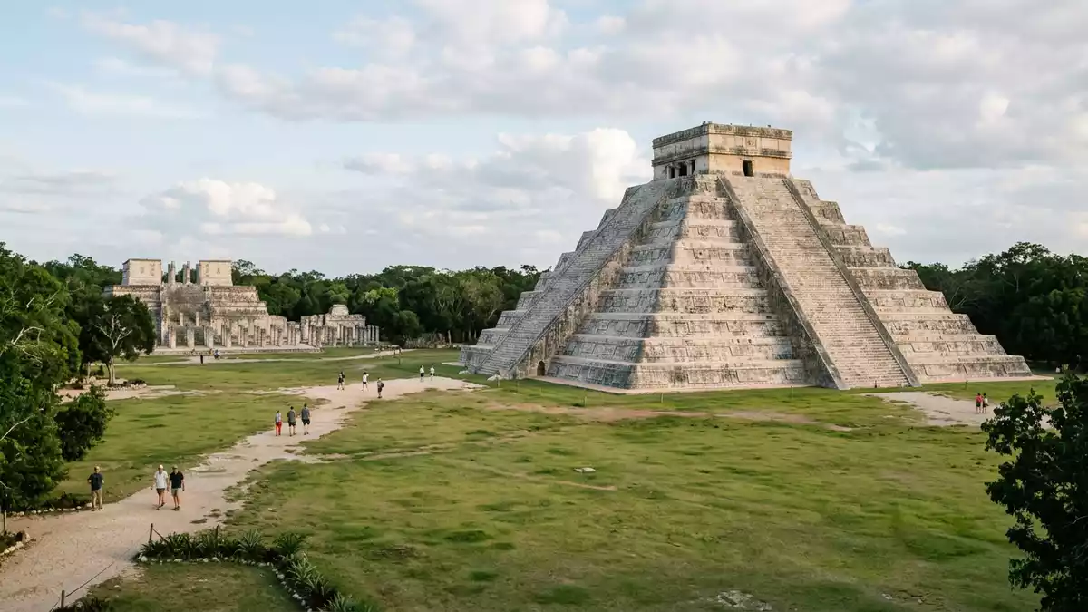
On the northern Yucatán plain in Mexico, west of Valladolid, the ancient city of Chichen Itza presents a broad ensemble of stone structures dominated by the stepped Kukulkan Pyramid. Built by Maya and Toltec-Maya builders between roughly the ninth and thirteenth centuries, this former urban centre now stands as one of the most studied archaeological sites in the region.
The Pre-Hispanic city and its setting
Chichen Itza occupies a low limestone plateau in Tinúm Municipality in Yucatán state, inland from the Caribbean coast and within reach of Valladolid as the nearest substantial town.Tinúm Municipality, Yucatán The city’s name refers to wells associated with the Itza people, reflecting the presence of natural sinkholes known as cenotes in the surrounding karst landscape.Pre-Hispanic City of Chichen-Itza The ruins lie on largely level ground, with groups of monumental buildings arranged around open plazas rather than against steep slopes or cliffs.
Across the archaeological zone, masonry structures in dressed limestone mark different phases of occupation, from earlier Maya constructions to later elements showing Toltec influence.Maya-Toltec city remains The broader site includes platforms, colonnades, ball courts, temples and observatory-like buildings, many aligned along axes that reflect planning decisions within the city’s ceremonial core.
Kukulkan Pyramid: a calendar in stone
The most recognisable structure at Chichen Itza is El Castillo, also known as the Temple of Kukulkan, a stepped pyramid rising from a square base in the main plaza.El Castillo, Temple of Kukulkan The pyramid reaches about 30 m (98 ft) in height when the summit temple is included, standing on a platform roughly 55 m (around 180 ft) wide on each side.platform 55.5 metres wide Its mass is broken into nine stepped terraces rising towards a rectangular temple block at the top.
Four staircases climb the faces of the pyramid, each counted with 91 steps; together with the top platform they form a total of 365, corresponding to days of a solar year.four staircases with 91 steps The terraces are subdivided into sections that match cycles in the Maya Haab’ calendar, and decorative panels echo the longer Calendar Round that linked solar and ritual calculations over 52 years.terraces marking months and calendar panels The building therefore acts as a three-dimensional expression of timekeeping, with number, proportion and arrangement built into its form.
Light, shadow and layers of construction
Beyond its stepped geometry, El Castillo is known for an equinox light-and-shadow effect on the staircase and serpent carvings on the northern side. On late afternoons around the spring and autumn equinoxes, the sun casts triangular shadows along the edge of the steps that appear to join the stone serpent heads at the base, creating the impression of a descending figure associated with Kukulkan.equinox shadow and serpent heads This interplay of sunlight and masonry has become one of the best documented visual phenomena at the site.
Investigations have shown that the visible pyramid envelops earlier structures, including a smaller internal pyramid with a jaguar-shaped throne and another core beneath.earlier pyramids within El Castillo Geophysical surveys using techniques such as electrical resistivity have indicated a cenote under the pyramid, linking the monument’s platform to an underground water-filled cavity in the limestone.cenote beneath the pyramid In the surrounding plaza, entrances to other cenotes punctuate the ground, giving visitors a sense of how surface architecture shares the landscape with natural openings.
Visiting Chichen Itza: what travellers from Western Europe should know
- Chichen Itza lies in Yucatán state in Mexico, inland on the peninsula and west of Valladolid, reached by road from that city and other regional centres.
- The archaeological zone is largely level but covers an extensive area; visiting the main groups of buildings involves walking over firm ground between plazas, platforms and cenotes.
- Spanish is the official language and the currency is the Mexican peso.
- Entry requirements depend on your nationality; UK travellers can check the FCDO travel advice at gov.uk/foreign-travel-advice, Irish travellers the Department of Foreign Affairs at ireland.ie.
Searching for Chichen Itza on social platforms
These links open searches for Chichen Itza on each platform.
Frequently asked questions about Chichen Itza
Where is Chichen Itza in relation to Valladolid?
Chichen Itza stands on the Yucatán Peninsula in Tinúm Municipality, west of Valladolid, and is reached from the city by regional highways through lowland forest.
What should visitors expect when walking around the site?
Visitors cross open plazas and paths between stone buildings on mainly level ground, with exposure to sun and occasional shade from trees and structures around the monuments.
What makes Chichen Itza distinctive among Maya sites?
The Kukulkan Pyramid combines stepped geometry, calendar-linked counts of steps and panels, a documented equinox shadow effect and evidence of internal pyramids and a cenote beneath its platform.


