
Cenote Ik Kil, a vertical world beside Chichen Itza
Published on 09/04/2026 at 07:37 | Editorial responsibility: Rafael Müller, Editor-in-Chief AD HOC NEWS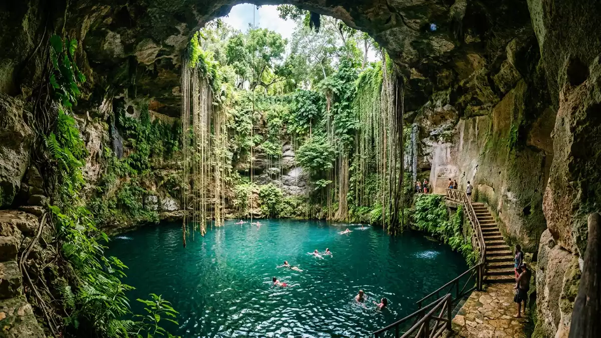
Cenote Ik Kil near Chichen Itza is a dramatic vertical pool where a shaft in the limestone drops to a ring of water far below ground level. The cenote lies in Yucatán in south-eastern Mexico, within the Ik Kil Archeological Park close to the famous Maya ruins of Chichen Itza, and its scale and near-cylindrical form make it one of the most distinctive natural features in the region.
A circular column of rock and water
Cenote Ik Kil is an open cenote, meaning that its roof has collapsed and its water is exposed to the sky inside a steep-sided shaft. The cenote stands near Pisté in the Tinúm Municipality of Yucatán, on the inland plateau of the northern Yucatán Peninsula, forming part of the Ik Kil Archeological Park that borders the archaeological zone of Chichen Itza.Tinúm Municipality From the rim, the rock falls to a pool whose surface is around 26 m (85 ft) below the surrounding ground, giving visitors a view straight down to the water.
The cenote itself measures about 60 m (200 ft) across, forming a broad circular basin inside the limestone.about 60 m wide The water reaches a depth of roughly 40–48 m (131–157 ft), so the space inside the shaft is tall and deep in all directions.about 48 m deep Vines and roots fall from the edge of the opening down the sides of the rock, and small waterfalls descend from the rim, so the shaft appears as a vertical garden above the pool.
Limestone, groundwater and the cenote landscape of Yucatán
Cenote Ik Kil belongs to the wider network of cenotes that mark the limestone plateau of Yucatán, where rock has dissolved and collapsed to reveal the groundwater beneath. The northern centre of the Yucatán Peninsula is made largely of porous limestone, and cenotes form where underground caverns intersect the surface, providing access to fresh water in a landscape without large rivers.fresh water in a park At Ik Kil that process has produced a near-cylindrical shaft with vertical walls, so the water sits as a deep pool at the base of an almost continuous ring of rock.
The name Ik Kil has a meaning connected with wind in the Maya language, and the cenote formed when the roof of a limestone cavern collapsed, leaving a broad circular opening above the water.formed when the roof collapsed In pre-Hispanic times cenotes around Chichen Itza were closely linked with Maya settlement, agriculture and ritual, because they provided permanent water on the karst plain. Ik Kil today lies within a landscaped ecological park, with paths and facilities around the rim, but the underlying structure – limestone walls, hanging vegetation and a pool of groundwater – reflects that older relationship between geology and water.
Descending into the pool at Ik Kil
Cenote Ik Kil is open to visitors as a swimming site, and the experience revolves around the descent from the bright plateau into the shaded interior of the shaft.access via a staircase A carved stone stairway winds down through the rock from the park level to platforms close to the water, passing openings that look into the shaft along the way. From these intermediate levels, the view takes in the full height of the walls, the hanging vines and the pool below, and the sense of being inside a vertical cylinder of stone is strong.
At water level, swimmers enter a pool that is deep even close to the edge, with the walls rising directly from the surface. The depth at the centre reaches several tens of metres, so the water column beneath a swimmer extends far below the platforms. The surface of the pool lies well below the surrounding land, and the rock above forms a high ring, so the sky appears as a relatively small disc above the water, contrasting with the enclosing rock and vegetation.
Visiting Cenote Ik Kil: what travellers from Western Europe should know
- Cenote Ik Kil lies in Yucatán in south-eastern Mexico, a short distance from the archaeological zone of Chichen Itza and near the town of Pisté. It stands beside Highway 180, the main road linking Chichen Itza with Valladolid.
- The descent into the cenote follows a stone stairway that drops from park level to platforms near the water, with many steps and sections that can feel narrow.
- The official language is Spanish and the currency is the Mexican peso.
- Entry requirements depend on your nationality; UK travellers can check the FCDO travel advice at gov.uk/foreign-travel-advice, Irish travellers the Department of Foreign Affairs at ireland.ie.
Searching for Cenote Ik Kil on social platforms
These links open searches for Cenote Ik Kil on each platform.Frequently asked questions about Cenote Ik Kil
Where is Cenote Ik Kil in relation to Chichen Itza?
Cenote Ik Kil lies in Yucatán in south-eastern Mexico, within the Ik Kil Archeological Park near the archaeological zone of Chichen Itza and close to the town of Pisté.
What should visitors expect when descending into the cenote?
Visitors follow a carved stone stairway from park level down the inside of the shaft to platforms near the water, passing viewpoints into the cenote and then reaching a deep pool surrounded by vertical limestone walls and hanging vegetation.
What makes Cenote Ik Kil distinctive among Yucatán cenotes?
Its near-cylindrical shaft, the considerable drop from ground level to the water surface and the combination of vertical limestone walls, hanging vines and small waterfalls give Cenote Ik Kil a strikingly vertical character, with the water forming a pool far below the surrounding land.


