
Cape of Good Hope, where ocean, cliff and trade routes meet
Published on 09/19/2026 at 06:56 | Editorial responsibility: Rafael Müller, Editor-in-Chief AD HOC NEWS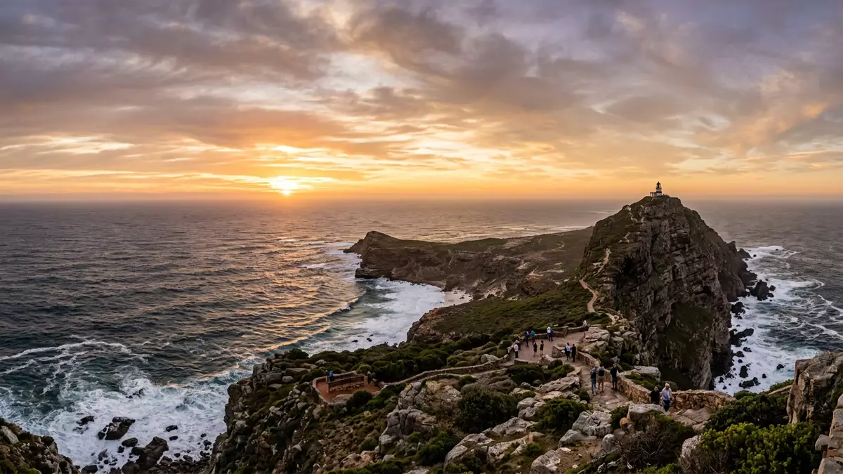
Cape of Good Hope, south of Kapstadt on the Cape Peninsula in South Africa, is a rocky Atlantic headland whose cliffs and currents have shaped centuries of ocean travel. It marks the south?western end of the peninsula and gave its name to the wider Cape Colony, tying a dramatic coastal landscape to a long imperial history.
Where the peninsula runs into the Atlantic
Geographically, Cape of Good Hope is a promontory on the Atlantic coast at the southern end of the Cape Peninsula, in South Africa’s Western Cape province.rocky promontory at the southern end The peninsula projects south from the mainland near Kapstadt, with the Atlantic to the west and False Bay opening on its eastern side.the southern end of Cape Peninsula The cape itself sits within the Cape of Good Hope section of Table Mountain National Park, part of the wider Cape Floral Region.
The headland is formed largely of hard Cape granite and sedimentary rocks of the Table Mountain Group, giving the coastline its sheer faces and irregular profile.Cape granite jutting into the Atlantic Offshore, the cape stands near the meeting zone of two major currents: warmer water from the Mozambique–Agulhas system moves down the Indian Ocean flank of southern Africa, while cooler Benguela waters rise along the Atlantic margin from Antarctic latitudes.convergence of warm and cool currents The interaction between these currents and the rugged coastline helps to produce energetic seas and changeable maritime conditions around the headland.
From Cape of Storms to Cape of Good Hope
The name Cape of Good Hope is rooted in late fifteenth?century ocean exploration. In approximately 1488, the Portuguese navigator Bartolomeu Dias led an expedition south along the Atlantic coast of Africa and became the first recorded European to round the cape.Portuguese navigator Bartolomeu Dias in 1488 Accounts describe Dias naming the headland Cabo das Tormentas, “Cape of Storms”, after experiencing severe weather and swell in the area, while King John II of Portugal substituted Cabo da Boa Esperança, “Cape of Good Hope”, in reference to the prospect of a sea route to India.from Cape of Storms to Cape of Good Hope
By demonstrating that ships could sail around southern Africa rather than being blocked by land, Dias and later voyagers opened the first all?water route from Europe to Asia along the Atlantic and Indian oceans.first all?water route from Europe to Asia Over subsequent centuries, almost every European trading vessel bound for India, East Africa or the Indonesian archipelago passed near these cliffs, making Cape of Good Hope a landmark of global maritime commerce and navigation.
Nature reserve, floral region and neighbouring headlands
Today Cape of Good Hope forms part of a nature reserve within Table Mountain National Park, protecting coastal fynbos vegetation, beaches and marine ecosystems along the southern Cape Peninsula.Cape of Good Hope nature reserve The reserve also encompasses Cape Point, the taller cliff east of the cape itself, where an old lighthouse stands above the ocean. The wider Cape Floral Region, recognised as a World Heritage Site, includes the peninsula’s distinctive plant communities.
For visitors, one visible contrast is between the low, wave?washed rocks at the Cape of Good Hope sign and the higher precipices around Cape Point within the same protected area.Cape of Good Hope Nature Reserve Inland, the reserve gives way to the rest of the Cape Peninsula and the metropolitan area of Kapstadt to the north, while further east along the coast lies Cape Agulhas, identified as the southernmost point of the African continent.not the southernmost point of Africa
Visiting Cape of Good Hope: what travellers from Western Europe should know
- Cape of Good Hope lies on the Cape Peninsula south of Kapstadt; road access runs through Table Mountain National Park to the reserve’s main gate near the Atlantic coast.
- The terrain includes coastal paths, uneven rock and sections of steps on viewpoints, so walking in the reserve involves short climbs and routes exposed to ocean wind.
- The official language is Afrikaans and English is widely used; the national currency is the South African rand.
- Entry requirements depend on your nationality; UK travellers can check the FCDO travel advice at gov.uk/foreign-travel-advice, Irish travellers the Department of Foreign Affairs at ireland.ie.
Searching for Cape of Good Hope on social platforms
These links open searches for Cape of Good Hope on each platform.
Frequently asked questions about Cape of Good Hope
Where is Cape of Good Hope in relation to Kapstadt?
Cape of Good Hope lies on the Cape Peninsula in South Africa’s Western Cape province, south of the metropolitan area of Kapstadt along the Atlantic coast.
What should travellers expect when visiting Cape of Good Hope?
Travellers encounter a coastal nature reserve with cliffs, Atlantic surf, fynbos vegetation and walking routes on uneven ground, including paths and stairways near viewpoints.
What makes Cape of Good Hope distinctive among African capes?
Cape of Good Hope combines a rugged Atlantic headland, interacting ocean currents and its fifteenth?century role in opening a European sea route to Asia.


