

Cape of Good Hope, where Atlantic cliffs frame Kapstadt’s far edge
Published on 09/07/2026 at 16:56 | Editorial responsibility: Rafael Müller, Editor-in-Chief AD HOC NEWS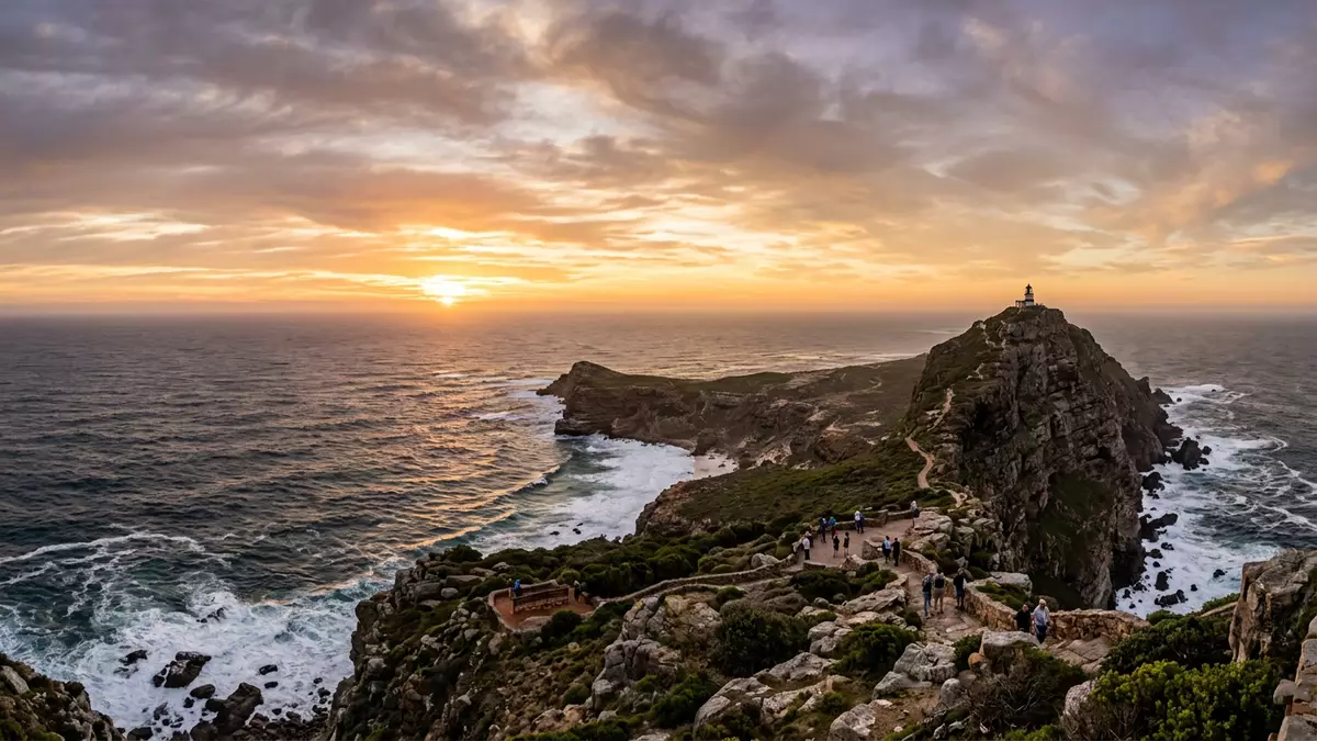
Cape of Good Hope is a rocky headland at the southern end of the Cape Peninsula in South Africa, where dark cliffs fall into Atlantic surf and ocean swells strike exposed rock.rocky promontory at the southern end South of central Kapstadt the peninsula narrows to a rugged tip, and here the coast, the currents and centuries of navigation share the same confined space.
Atlantic headland at the tip of the Cape Peninsula
Cape of Good Hope lies on the Atlantic coast of the Cape Peninsula in South Africa, near its southern tip where the land projects into the South Atlantic.rocky headland on the Atlantic coast From the city, the peninsula runs southward past Table Mountain and other peaks before ending in a series of cliffs, promontories and boulder shores around the cape.
The headland forms part of the western boundary of False Bay and sits a substantial distance south of Table Bay, where Kapstadt grew around its natural harbour.forms the western boundary of False Bay It is not the southernmost point of Africa; that title belongs to Cape Agulhas further east along the coast, but the position of Cape of Good Hope at the end of the peninsula makes it an obvious landmark from land and sea.not the southernmost point of Africa
Where ocean currents and Cape Peninsula geology meet
The cliffs around Cape of Good Hope expose resistant rocks of the Cape Supergroup, the same family of sandstones that shape Table Mountain and other heights along the peninsula.Cape Supergroup sandstones Sea and wind have cut these layers into ledges and buttresses that drop to rocky beaches and narrow strips of sand, with breaking waves sending spray back up towards the plateau above.
Offshore, the waters around the cape stand at the meeting point of two major systems: warm water flows southwards in the Mozambique–Agulhas current along the Indian Ocean margin, while the Benguela current brings cooler water northwards along the Atlantic side from Antarctic latitudes.convergence of warm and cool currents Their interaction contributes to energetic seas around the headland, a factor that helped give Cape of Good Hope its reputation among sailors as a place of strong winds and rough water.
Age of Exploration landmark at the end of Africa
Long before modern charts and satellite navigation, Cape of Good Hope became a pivotal landmark in the Age of Exploration. In 1488 the Portuguese navigator Bartolomeu Dias led the first documented European expedition to round the cape, demonstrating that ships could sail around Africa’s southern tip and continue into the waters leading toward the Indian Ocean.first European expedition to round the cape Dias’s voyage helped establish the longer sea route to Asia that bypassed overland passages.
A decade later Vasco da Gama followed the route around Cape of Good Hope on his pioneering voyage to India in 1497–1498, building directly on the path Dias had traced.rounded the cape in 1497 Commemorative crosses and beacons erected by Portuguese authorities near the cape recall Dias and da Gama as early European navigators associated with this coastline.Dias Cross and da Gama Cross For travellers approaching from Kapstadt, Cape of Good Hope sits within Table Mountain National Park, itself part of the wider Cape Floral Region recognised as a World Heritage Site for its rich plant diversity.nature reserve within Table Mountain National Park
Visiting Cape of Good Hope: what travellers from Western Europe should know
- Cape of Good Hope lies south of Kapstadt at the end of the Cape Peninsula, reached by road that follows the coast through suburbs and coastal settlements towards the headland.
- The terrain around the cape combines paved routes with rougher paths over uneven rock and sand, with noticeable gradients between parking areas, viewpoints and the shoreline.
- The headland sits within Table Mountain National Park, so natural vegetation, cliffs and wildlife are part of the surroundings rather than separate from the visit.
- English and Afrikaans are widely used in South Africa, and the national currency is the South African rand.
- Entry requirements depend on your nationality; UK travellers can check the FCDO travel advice at gov.uk/foreign-travel-advice, Irish travellers the Department of Foreign Affairs at ireland.ie.
Searching for Cape of Good Hope on social platforms
These links open searches for Cape of Good Hope on each platform.Frequently asked questions about Cape of Good Hope
Where is Cape of Good Hope in relation to Kapstadt?
Cape of Good Hope sits at the southern end of the Cape Peninsula in South Africa, a substantial distance south of Kapstadt’s Table Bay coastline along the Atlantic side.
What should travellers expect when visiting the cape?
Travellers encounter exposed Atlantic cliffs, rocky shores and natural vegetation within Table Mountain National Park, together with paved viewpoints and rougher paths linking different levels.
What makes Cape of Good Hope distinctive among African capes?
The cape combines a prominent Atlantic headland on the Cape Peninsula with the meeting of major ocean currents and a documented role in voyages by Bartolomeu Dias and Vasco da Gama during the Age of Exploration.


