
Cap de Formentor, where Mallorca’s mountains meet the sea
Published on 09/19/2026 at 15:58 | Editorial responsibility: Rafael Müller, Editor-in-Chief AD HOC NEWS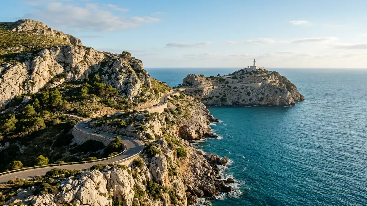
Cap de Formentor marks the northern tip of Mallorca, a narrow peninsula where the final ridges of the Serra de Tramuntana drop into the Mediterranean in a spine of cliffs and bays. On this headland the road, the rock and the sea come together at a lighthouse that has watched over these waters since the nineteenth century.
A rocky peninsula at the end of Mallorca
Cap de Formentor forms the outer end of the Formentor peninsula, a tongue of land that reaches north-east from the main bulk of Mallorca and narrows towards the sea. The cape belongs to the municipality of Pollença in the island’s far north, and its position makes it the northernmost point of Mallorca.northernmost point of Mallorca
The peninsula is part of the Serra de Tramuntana, the mountain chain that runs along Mallorca’s northern edge and is recognised as a cultural landscape by UNESCO.northern tip of the Serra de Tramuntana Here the range ends in steep coastal cliffs, with ravines and small coves cut into the rock, including the bays of Cala Murta and Platja de Formentor that sit on the sheltered side of the headland.bays like Cala Murta and Platja de Formentor
The lighthouse and the engineer’s road
On the extreme tip of the peninsula stands the Faro de Cap de Formentor, a lighthouse completed in 1863 under the engineer Emili Pou.lighthouse completed in 1863 It sits high above the sea on the cliff edge, with its focal plane recorded as one of the highest in the Balearic archipelago. The building itself is a compact complex of keeper’s quarters and service structures around the tower, set on a terrace of masonry that clings to the rock.
Reaching the lighthouse has long been part of the appeal of Cap de Formentor. The Ma-2210 road winds out from Port de Pollença along the length of the peninsula, following the ridge and cutting across slopes on narrow switchbacks. This road was laid out in the early twentieth century and is associated with the Mallorcan engineer Antonio Parietti, whose work also includes other mountain routes on the island.winding road from Port de Pollença Along the way are viewpoints where the cliffs drop directly into the water and the peninsula’s bays and offshore rocks come into view.
Wind, height and views over the bay of Pollença
The Majorcans call Cap de Formentor the “meeting point of the winds”, a name that reflects its exposed position between the open sea and the bay of Pollença.meeting point of the winds The cape closes the bay on its northern side, and from its higher ground the outline of the bay curves away towards Alcúdia and the lower coast. The highest point on the headland, Fumat, rises to 384 m (1,260 ft) above sea level, giving the peninsula a marked relief over the water below.peak of Fumat at 384 m
Much of the Formentor peninsula is covered with Mediterranean vegetation, including pine woodland and scrub on the slopes, while the steeper faces remain bare rock. From the viewpoints along the Ma-2210 and around the lighthouse terrace, the views run south to the Serra de Tramuntana peaks, across the bay towards Alcúdia and out over open water towards the Gulf of Lion. The combination of height, open exposure and the long reach of the peninsula into the sea makes Cap de Formentor one of Mallorca’s clearer examples of how the island’s mountains and coastline meet.
Visiting Cap de Formentor: what travellers from Western Europe should know
- Cap de Formentor lies in the municipality of Pollença in northern Mallorca, at the tip of the Formentor peninsula, and is reached by road Ma-2210 from Port de Pollença.
- The terrain on the peninsula is mountainous, with steep coastal cliffs, winding roads with tight bends and viewpoints reached by short walks over uneven ground.
- Platja de Formentor and Cala Murta sit on the more sheltered side of the peninsula, providing bays with beaches and coastal paths within the same headland area.
- The official language is Spanish and the currency is the euro.
Searching for Cap de Formentor on social platforms
These links open searches for Cap de Formentor on each platform.
Frequently asked questions about Cap de Formentor
Where is Cap de Formentor on Mallorca?
Cap de Formentor sits at the northern tip of Mallorca on the Formentor peninsula, within the municipality of Pollença in the island’s north.
What should visitors expect on a trip to Cap de Formentor?
Visitors encounter a mountain peninsula of steep coastal cliffs, a winding road with viewpoints, bays such as Platja de Formentor and a nineteenth-century lighthouse above the sea.
What makes Cap de Formentor distinctive among Mallorca’s coastal landscapes?
Cap de Formentor combines the Serra de Tramuntana’s final ridges with high cliffs, exposed viewpoints and a long peninsula that reaches out into open water at a historic lighthouse.


