
Cap de Formentor, where Mallorca narrows into sea and sky
Published on 09/07/2026 at 18:43 | Editorial responsibility: Rafael Müller, Editor-in-Chief AD HOC NEWS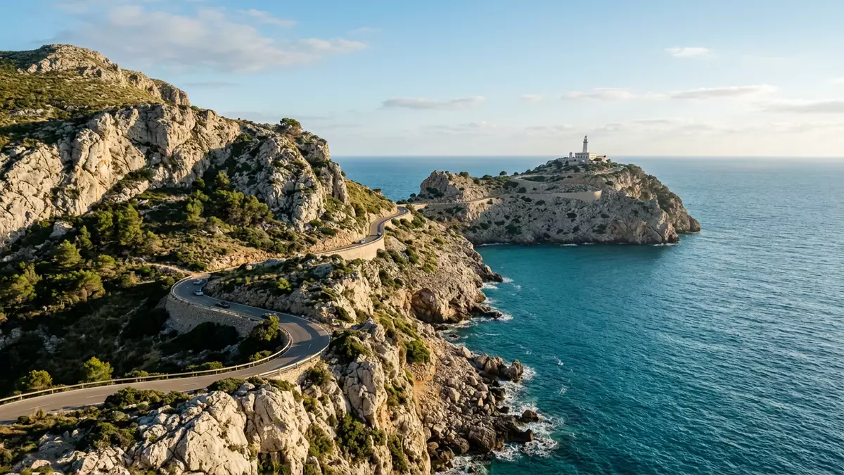
At Cap de Formentor, Mallorca tapers to a narrow peninsula of rock before dropping into the Mediterranean in sheer cliffs and hidden coves. On this northernmost point of the island, the Serra de Tramuntana reaches its seaward end in a landscape shaped by limestone, wind and waves, watched over by a nineteenth-century lighthouse on the final headland.Cap de Formentor is the northernmost point of Mallorca.
Where the Serra de Tramuntana meets the sea
Cap de Formentor lies on the Formentor peninsula in the municipality of Pollença, a spit of land that projects north-east from the main body of Mallorca. The peninsula is around 20 km long, forming the final section of the Serra de Tramuntana before the mountains give way to the open water of the Mediterranean.Cap de Formentor marks the end of the Formentor peninsula and closes the Bay of Pollença on its northern side.The cape lies at the septentrional extremity of Mallorca
The terrain here is steep and broken, with high cliffs dropping to small inlets such as Cala Murta and Platja de Formentor, a beach known for pale sand and clear water under pine trees.The highest point on the cape, Fumat, reaches 384 m above sea level, giving views over the Serra de Tramuntana range and out towards the open sea. The rocky slopes carry Mediterranean vegetation and scattered trees, with the sea visible between trunks and above the headlands.
The road to the Formentor lighthouse
A single sinuous road runs along the spine of the peninsula from the vicinity of Port de Pollença towards the headland, curving around ridges and saddles before turning towards the final point. The route climbs and descends between viewpoints, occasionally revealing the drop to the water beside the asphalt. It was built across a rocky formation that extends into the sea like a pier, giving access along the full length of the cape.An 18 km road leads to Cap de Formentor on a rocky spur.
At the end of this road stands the Formentor lighthouse, set on a rocky promontory above the sea. The light was designed by Emili Pou and opened on 30 April 1863, part of the nineteenth-century effort to improve navigation around the Balearic Islands.Formentor lighthouse was inaugurated in 1863 and designed by Emili Pou. Its focal plane stands higher above sea level than any other lighthouse in the Balearic archipelago, and the building looks over terraces, rock slopes and the water beyond.
Headlands, coves and the meeting point of the winds
The peninsula has long carried the local nickname “meeting point of the winds”, a reflection of the way air currents cross at this projection into the sea.Cap de Formentor is affectionately known as the meeting point of the winds. When standing on the higher points, the sea extends on three sides, with the line of the Serra de Tramuntana trailing away to the south-west. On clear days the outline of distant cliffs and bays appears along the coast, while below the cape the water cuts into small coves.
Among these is Platja de Formentor, a long, narrow beach backed by trees and facing the protected waters of the bay. Inland, the road passes by viewpoints where the land falls sharply away and rock faces hang above the sea. From the lighthouse, the horizon is largely water, with the arc of the coastline visible in the distance and the serrated line of Tramuntana peaks marking Mallorca’s interior.The cape connects dramatic cliffs, viewpoints and hidden beaches.
Visiting Cap de Formentor: what travellers from Western Europe should know
- Cap de Formentor lies in the municipality of Pollença on the northern tip of Mallorca. It is reached by road from Port de Pollença along the Formentor peninsula, with buses running between local towns and the cape.
- The terrain around the cape includes steep gradients and cliff edges, and the approach to the lighthouse uses a winding mountain road. Paths and viewpoints involve uneven ground and short walks on rock or paved surfaces.
- The peninsula forms part of the Serra de Tramuntana mountain region on Mallorca’s north coast. Inland routes connect it with other viewpoints along the range and with coastal settlements such as Port de Pollença.
- The official language is Spanish and the currency is the euro.
Searching for Cap de Formentor on social platforms
These links open searches for Cap de Formentor on each platform.
Frequently asked questions about Cap de Formentor
Where is Cap de Formentor on Mallorca?
Cap de Formentor is on the Formentor peninsula in the municipality of Pollença, forming the northernmost point of Mallorca and closing the Bay of Pollença to the north.
What should visitors expect on a visit to Cap de Formentor?
Visitors encounter a narrow peninsula of limestone cliffs, small coves and viewpoints, reached by a winding mountain road and culminating in the Formentor lighthouse above the sea.
What makes Cap de Formentor distinctive among Mallorca’s coastal landscapes?
The cape combines the final outcrop of the Serra de Tramuntana with a nineteenth-century lighthouse on a remote headland, surrounded by steep cliffs, coves and views over the Mediterranean.


