
Cap de Formentor, where Mallorca ends in cliffs and sea
Published on 08/17/2026 at 13:43 | Editorial responsibility: Rafael Müller, Editor-in-Chief AD HOC NEWS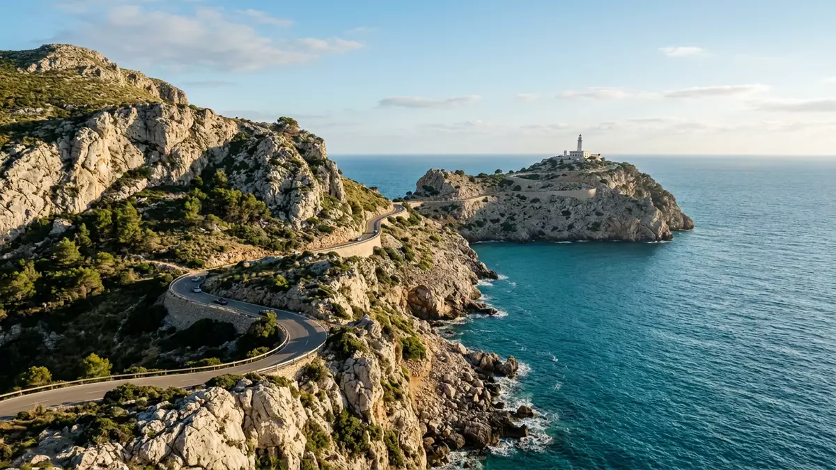
Cap de Formentor is the northernmost headland of Mallorca, a long limestone peninsula where the Serra de Tramuntana meets the Mediterranean in a sudden wall of cliffs. Rising above the sea and ending at a lighthouse on a rocky promontory, it forms the outer edge of the municipality of Pollença and marks the end of the island’s northern coast.
A peninsula of rock, wind and height
Cap de Formentor occupies the far tip of the Formentor peninsula, a narrow strip of land that stretches north-east from Port de Pollença into the sea and is often described simply by its name.The spit of land ends where the cliffs drop towards the lighthouse and the sea beyond. The peninsula forms the northern limit of the Serra de Tramuntana and closes the Bay of Pollença on its northern side, giving the headland a clear geographical role as the end of Mallorca’s main mountain chain.It marks the limit
The rock here is cut into steep faces that fall to the water, with the highest point of the peninsula, Fumat, reaching 384 m (1,260 ft) above sea level.Its highest point Fumat A sinuous road follows the crest and flanks of the ridge, offering views down over pine woods, inlets and narrow coves such as Cala Murta and Cala Pi de la Posada, also known as Platja de Formentor.The associated coves The sense of exposure grows towards the end of the peninsula, as the mountains narrow and the land tapers into a series of rocky promontories surrounded by water on almost every side.
The Formentor lighthouse at Mallorca’s land’s end
At the outer tip of Cap de Formentor stands the Formentor lighthouse, built in the nineteenth century to guide ships along the north coast of Mallorca.Construction began in 1857 It sits on a rocky outcrop above the sea, reached by the winding Ma-2210 road as it climbs and curves along the peninsula. From the area around the lighthouse, the view opens in several directions: down over broken cliffs and terraces of rock, across the open Mediterranean and back towards the ridge of the Serra de Tramuntana marching along Mallorca’s spine.
The road itself has become a recognised part of the experience of visiting Cap de Formentor. Beginning near Port de Pollença, the Ma-2210 climbs past viewpoints and the beach of Formentor, then continues in tight bends and short tunnels towards the lighthouse at the end.The scenic Ma-2210 road Travellers encounter a sequence of vantage points, each with a different angle on the cliffs and the peninsula. Some look back towards the main island, others out to sea, and others down into small bays that appear cut into the rock like amphitheatres.
Beaches, coves and the meeting point of the winds
Despite its reputation for cliffs and exposure, Cap de Formentor also includes a sheltered side. On the inner shore of the peninsula lies Platja de Formentor, sometimes called Formentor Beach or Playa Formentor, a sandy beach framed by pine trees and clear water.Playa Formentor under the pines From here, the mountains rise behind the beach, giving swimmers and visitors a direct view of the ridge that leads out towards the cape.
The headland is known locally as a meeting point for winds, a reference to the way breezes from different directions converge around the tip of the island.Meeting point of the winds Out on the cliffs and at the lighthouse, this can translate into swiftly changing conditions, with the sea below showing ripples and swells moving along different lines. Inland, the pine woods and scrubland of the peninsula soften the landscape, providing shade along some sections of the road and paths, and a contrast to the bare limestone faces that drop directly to the water.
Visiting Cap de Formentor: what travellers from Western Europe should know
- Cap de Formentor lies in the municipality of Pollença at the northern tip of Mallorca; the Ma-2210 road from Port de Pollença leads along the peninsula to the lighthouse.
- The terrain combines steep, exposed cliff faces with wooded slopes and narrow roadside viewpoints; approaches near the lighthouse involve gradients and roadside drops without broad verges.
- The headland forms part of the Serra de Tramuntana range, so weather can change quickly along the ridge, with conditions on the cliffs differing from those on the lowland coast.
- Other notable features nearby include Platja de Formentor on the inner shore of the peninsula and small coves such as Cala Murta reached from side roads and paths.
- The official language is Spanish and the currency is the euro.
Searching for Cap de Formentor on social platforms
These links open searches for Cap de Formentor on each platform.
Frequently asked questions about Cap de Formentor
Where is Cap de Formentor on Mallorca?
Cap de Formentor is at the northernmost tip of Mallorca in Spain, within the municipality of Pollença, forming the end of the Formentor peninsula and the Serra de Tramuntana.
What should travellers expect on a visit to Cap de Formentor?
Travellers encounter a winding mountain road, steep limestone cliffs, pine woods, viewpoints over the Mediterranean and the nineteenth-century Formentor lighthouse at the end of the peninsula.
What makes Cap de Formentor distinctive among Mallorca’s coasts?
Its role as Mallorca’s northern land’s end, combining high cliffs and ridge roads with coves and the sheltered Platja de Formentor, gives the peninsula a mix of exposure and protection that is specific to this corner of the island.


