

Caminito del Rey and the clifftop path through Desfiladero de los Gaitanes
Published on 08/26/2026 at 11:31 | Editorial responsibility: Rafael Müller, Editor-in-Chief AD HOC NEWS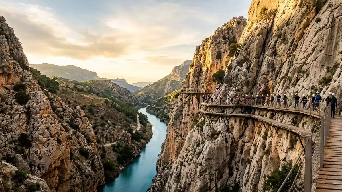
High above the Guadalhorce River in southern Spain, Caminito del Rey traces a narrow walkway along the cliffs of the Desfiladero de los Gaitanes near Ardales in the province of Málaga. Built in the early twentieth century as an access route for hydroelectric works and inaugurated by King Alfonso XIII in 1921, it has since become a striking clifftop path that follows the gorge for several kilometres.Desfiladero de los Gaitanes
A walkway pinned to the limestone gorge
Caminito del Rey runs along the steep walls of the Desfiladero de los Gaitanes, a gorge carved by the Guadalhorce River between Ardales and Álora in Andalusia.a walkway pinned along the steep walls The path begins in the municipality of Ardales, crosses a short section of Antequera and finishes near El Chorro in Álora, following the course of the river through high limestone walls.It starts in Ardales and concludes in El Chorro
The core elevated walkway extends for about 3 km (1.9 miles), with additional access paths bringing the total signposted route to around 8 km (5 miles) from entrance to exit.a length of 3 kilometres Sections of the path are about 1 metre wide, anchored directly to the rock and hanging around 100 m (328 ft) above the river, giving clear views down into the gorge and across to the opposite cliff face.about 1 metre wide and up to 105 metres above the river
From industrial service path to restored route
The origins of Caminito del Rey lie in the development of hydroelectric power in this part of Málaga province in the early twentieth century. The company Sociedad Hidroeléctrica del Chorro built a water channel and two power stations in the Desfiladero de los Gaitanes, and between 1901 and 1905 an access path was constructed along the cliff to maintain the canal and reach the installations.aerial path built for the Desfiladero de los Gaitanesconstruction of the original path between 1901 and 1905
In 1921 King Alfonso XIII crossed the walkway during a visit to the nearby El Chorro dam, and the path became known as El Caminito del Rey, “the King’s little path”.inaugurated by King Alfonso XIII on 21 May 1921 The original structure used concrete slabs supported by steel beams fixed into the limestone, hugging the rock face high above the river channel.built mainly from concrete, wood and steel
Walking the linear route between Ardales and Álora
The modern route of Caminito del Rey is a linear trail that runs in one direction from north to south, starting near the reservoirs by Ardales and ending near the railway halt at El Chorro in the municipality of Álora.linear route from Ardales to Álora The overall distance from the northern access to the southern exit is around 8 km (5 miles), combining forest paths, tunnels and boardwalks suspended above the river.a 7.7 kilometre linear trail
Most itineraries follow a descending profile from the Ardales side through pine woodland into the Desfiladero de los Gaitanes and on to the narrower gorge by El Chorro, where the final section includes a hanging walkway and a bridge high over the water. The combination of engineered walkways, steep rock faces and the river far below gives the route a distinctive character within the wider landscape of inland Málaga.
Visiting Caminito del Rey: what travellers from Western Europe should know
- Caminito del Rey lies north-west of Málaga in Andalusia, with the trail starting near the reservoirs by Ardales and finishing by the El Chorro railway halt in Álora.
- The elevated sections are attached to steep limestone walls high above the Guadalhorce River, and parts of the route follow narrow paths and boardwalks exposed to height.
- The official language is Spanish and the currency is the euro.
- Entry requirements depend on your nationality; UK travellers can check the FCDO travel advice at gov.uk/foreign-travel-advice, Irish travellers the Department of Foreign Affairs at ireland.ie.
Searching for Caminito del Rey on social platforms
These links open searches for Caminito del Rey on each platform.
Frequently asked questions about Caminito del Rey
Where is Caminito del Rey?
Caminito del Rey is in the province of Málaga in Andalusia, beginning near Ardales and ending near El Chorro in the municipality of Álora.
What kind of route is Caminito del Rey?
It is a linear walking route that combines access tracks and elevated boardwalks attached to the limestone cliffs of the Desfiladero de los Gaitanes above the Guadalhorce River.
What makes Caminito del Rey distinctive?
The route follows a narrow elevated path anchored to vertical rock walls high above a river gorge, tracing an early twentieth-century industrial service walkway through a dramatic landscape.


