
Caminito del Rey: a cliff-hugging path through a Spanish gorge
Published on 09/07/2026 at 22:59 | Editorial responsibility: Rafael Müller, Editor-in-Chief AD HOC NEWS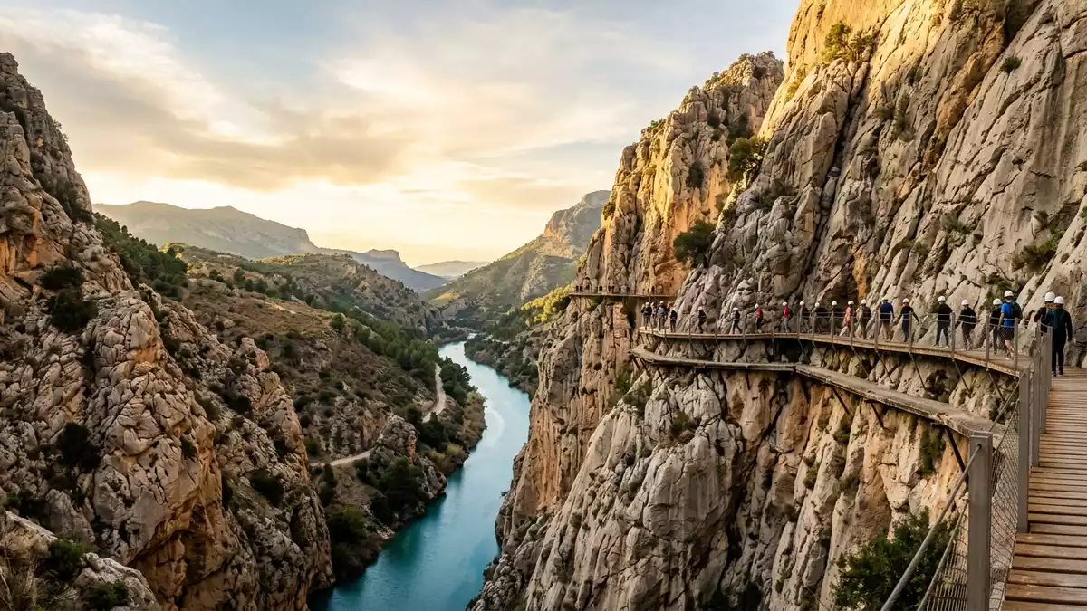
Caminito del Rey is a narrow walkway clinging to the walls of a limestone gorge in the province of Málaga, carrying visitors above the river between Ardales and El Chorro in southern Spain. Built in the early twentieth century as an access route for hydroelectric works and later associated with King Alfonso XIII, it has become a celebrated way to experience the dramatic Desfiladero de los Gaitanes from within the rock itself.
A walkway born from hydroelectric engineering
The story of Caminito del Rey begins with the construction of hydroelectric facilities along the Guadalhorce river at Chorro Falls and Gaitanejo Falls in the province of Málaga.Chorro Falls and Gaitanejo Falls Engineers from the Sociedad Hidroeléctrica del Chorro required a secure way for workers to move between sites, inspect channels and transport materials through the steep-sided gorge.Sociedad Hidroeléctrica del Chorro
Construction of the original path began in 1901 and was completed in 1905, creating a suspended passage fixed directly to the rock high above the river.constructed between 1901 and 1905 In 1921 King Alfonso XIII travelled to the Conde de Guadalhorce dam, crossing part of this elevated route during the inauguration of the reservoir, and the path acquired the name that translates as “the King’s little walk”.Conde de Guadalhorce dam inauguration
Through the Desfiladero de los Gaitanes
The modern trail follows the Desfiladero de los Gaitanes, a deep limestone gorge carved by the Guadalhorce river and protected as a natural park that spans the municipalities of Ardales, Álora and Antequera.Desfiladero de los Gaitanes Natural Park The route is linear, beginning near Ardales at the northern entrance and ending near El Chorro in Álora at the southern exit, so walkers progress in one direction through the gorge rather than returning along the same structure.linear route from Ardales to Álora
In total, the trail is described as about 7.7 km long, combining approach paths with the elevated walkways attached directly to the cliff face, which carry visitors tens of metres above the river along stretches of metal and timber decking.7.7 km linear walking trail Some sections run above very narrow parts of the gorge where the walls close in over the water, while others open out towards reservoirs and broader valleys, so the character of the landscape shifts between enclosed rock corridor and wider Andalusian scenery.
Walking above the Guadalhorce river today
For travellers, the attraction of Caminito del Rey lies in tracing an industrial-era path along structures anchored into near-vertical limestone, with the Guadalhorce river far below. The modern walkways follow the course of the original route but use renewed materials and railings, forming platforms and bridges that allow visitors to look down into the gorge and across to its opposing walls.
Approach paths lead through pine and holm oak woodland towards the gorge before joining the elevated sections, so a visit combines forest trails with suspended passages and viewpoints over the reservoirs created by early twentieth-century dams.route description through woodland and gorge From Ardales, the access route passes a pedestrian tunnel and then enters the narrowing gorge, while at the El Chorro end the trail emerges beside the railway and surrounding hills of the Málaga interior.trail between Ardales and El Chorro
Visiting Caminito del Rey: what travellers from Western Europe should know
- Caminito del Rey lies in the province of Málaga in southern Spain, with the northern access near Ardales and the southern exit near El Chorro in the municipality of Álora.
- The route crosses rugged limestone terrain above the Guadalhorce river, including elevated walkways fixed to cliffs and sections with steps and narrow passages.
- The area is reached by road from towns in inland Málaga, and the southern end at El Chorro connects with railway services running through the valley.
- The official language is Spanish and the currency is the euro.
- Entry requirements depend on your nationality; UK travellers can check the FCDO travel advice at gov.uk/foreign-travel-advice, Irish travellers the Department of Foreign Affairs at ireland.ie.
Searching for Caminito del Rey on social platforms
These links open searches for Caminito del Rey on each platform.
Frequently asked questions about Caminito del Rey
Where is Caminito del Rey?
Caminito del Rey is in the province of Málaga in Andalusia, Spain, crossing the Desfiladero de los Gaitanes between the municipalities of Ardales and Álora.
What should visitors expect on the route?
Visitors follow a linear trail that combines forest approaches with elevated walkways attached to limestone cliffs above the Guadalhorce river, including narrow sections and viewpoints.
What makes Caminito del Rey distinctive among Spanish hiking routes?
Its distinctive character comes from the combination of early twentieth-century hydroelectric history, association with King Alfonso XIII and the experience of walking high within a deep gorge on structures fixed to bare rock.


