
Calzada de Amador, where Panama-Stadt steps into the Pacific
Published on 09/15/2026 at 17:11 | Editorial responsibility: Rafael Müller, Editor-in-Chief AD HOC NEWS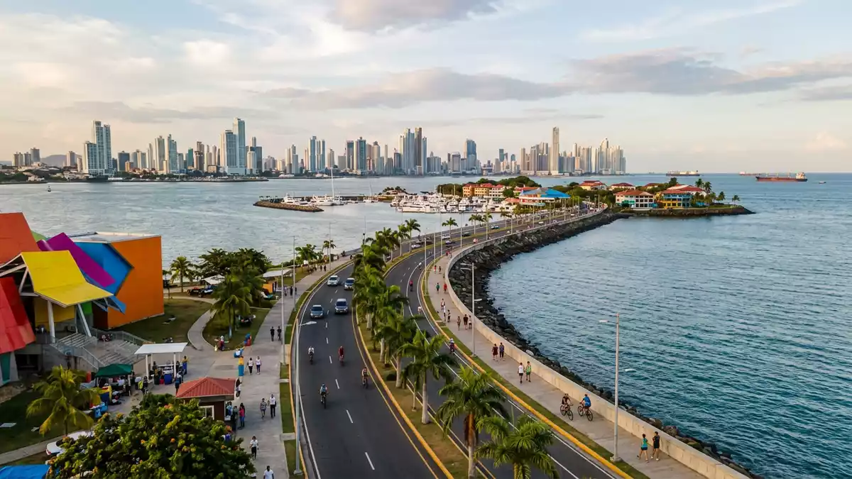
Calzada de Amador is the seafront road and promenade that leads Panama-Stadt out into the Pacific, resting on rock excavated during the construction of the Panama Canal in the early twentieth century. Built in 1913 under United States administration, it connects the city’s mainland to a chain of small islands while acting as a breakwater at the canal’s southern entrance.
A strip of canal rock reaching four Pacific islands
Calzada de Amador runs as a long, low causeway from the edge of Panama-Stadt towards the Pacific entrance of the Panama Canal, forming a slender peninsula of reclaimed ground in the bay. The roadway was formed using huge quantities of rock and soil taken from the Culebra Cut during canal excavation, turning spoil from one of the canal’s most demanding engineering sections into a permanent coastal structure.Built in 1913 with rock from the Culebra Cut The causeway links the mainland with a group of small islands that once stood offshore, tying them together with a continuous ribbon of land.
The road and walkway connect Naos, Perico, Culebra and Flamenco, a quartet of islands that together are known as the Causeway Islands.Four small islands by the Pacific entrance Along the route, the carriageway runs beside a dedicated path reserved for walking, jogging and cycling, so the whole length functions as a promenade as much as a road. Palm trees, low planting and occasional sculptures line stretches of the seafront, and the views open out towards the Bridge of the Americas, the canal channel and the islands further out in the gulf.
From strategic breakwater to waterfront promenade
When Calzada de Amador was first constructed, its role was primarily defensive and technical rather than recreational. The causeway acted as a breakwater for ships using the Pacific entrance to the Panama Canal, shielding the approaches from incoming swell and reducing the movement of sediment near the channel.Constructed using material excavated during canal works It also became part of a wider military complex, with installations positioned along the islands to protect the canal.
Fort Grant and Fort Amador were established on and around the causeway in the twentieth century, forming a defensive belt at the canal’s Pacific end.Fort Amador and Fort Grant protected the southern entrance Although the military role has receded, traces of that era remain in structures and embankments. In later decades, the shoreline was opened up and landscaped, and Calzada de Amador developed into a leisure waterfront with restaurants, marinas and viewing points layered onto the original engineering work.
Waterfront views, museums and island life
Walking or cycling along Calzada de Amador reveals a sequence of different outlooks on Panama-Stadt and its maritime setting. On one side, the skyline of the city rises behind the bay, with towers and office blocks above the older quarters; on the other, the view takes in the canal entrance, anchored ships and the low profile of the distant Taboga Island.The causeway offers views of the canal entrance and city skyline The causeway’s position allows a clear look at the Bridge of the Americas, which carries the Pan-American Highway over the canal near its Pacific end.
Each island along Calzada de Amador has its own character. Naos is associated with marine science facilities, including research centres focused on the tropical Pacific. Perico and Culebra have marinas, residential areas and small-scale services. Flamenco, at the far end, hosts the largest marina complex on the causeway and a ferry terminal where boats depart for islands further out in the Gulf of Panama.The road runs from the mainland out to four islands in sequence Across the causeway, bike rental outlets, cafés and open terraces make use of the uninterrupted views over water.
Visiting Calzada de Amador: what travellers from Western Europe should know
- Calzada de Amador extends from the south-western edge of Panama-Stadt towards the Pacific entrance of the Panama Canal, linking the mainland road network to the islands of Naos, Perico, Culebra and Flamenco.
- The terrain along the causeway is largely level, with a paved roadway and a separate path for walking and cycling that runs beside the water over an extended distance.
- Calzada de Amador lies within Panama City’s urban area, reached by road from districts such as Ancón and connected to the city’s transport hubs by public bus routes.
- The official language is Spanish and the currency is the Panamanian balboa, which is used alongside the United States dollar.
- Entry requirements depend on your nationality; UK travellers can check the FCDO travel advice at gov.uk/foreign-travel-advice, Irish travellers the Department of Foreign Affairs at ireland.ie.
Searching for Calzada de Amador on social platforms
These links open searches for Calzada de Amador on each platform.
Frequently asked questions about Calzada de Amador
Where is Calzada de Amador located?
Calzada de Amador is on the Pacific side of Panama-Stadt, near the southern entrance of the Panama Canal, linking the mainland with the islands of Naos, Perico, Culebra and Flamenco.
What can visitors expect on a visit to Calzada de Amador?
Visitors encounter a long waterfront road with a separate path for walking and cycling, views over the canal entrance and city skyline, and access to marinas, cafés and island facilities.
What makes Calzada de Amador distinctive among Panama-Stadt’s waterfronts?
Calzada de Amador is distinctive because it is built from canal excavation rock as a breakwater, connects multiple Pacific islands to the city and still carries traces of its former military role.


