

Calzada de Amador, where Panama City meets the Pacific
Published on 08/26/2026 at 18:42 | Editorial responsibility: Rafael Müller, Editor-in-Chief AD HOC NEWS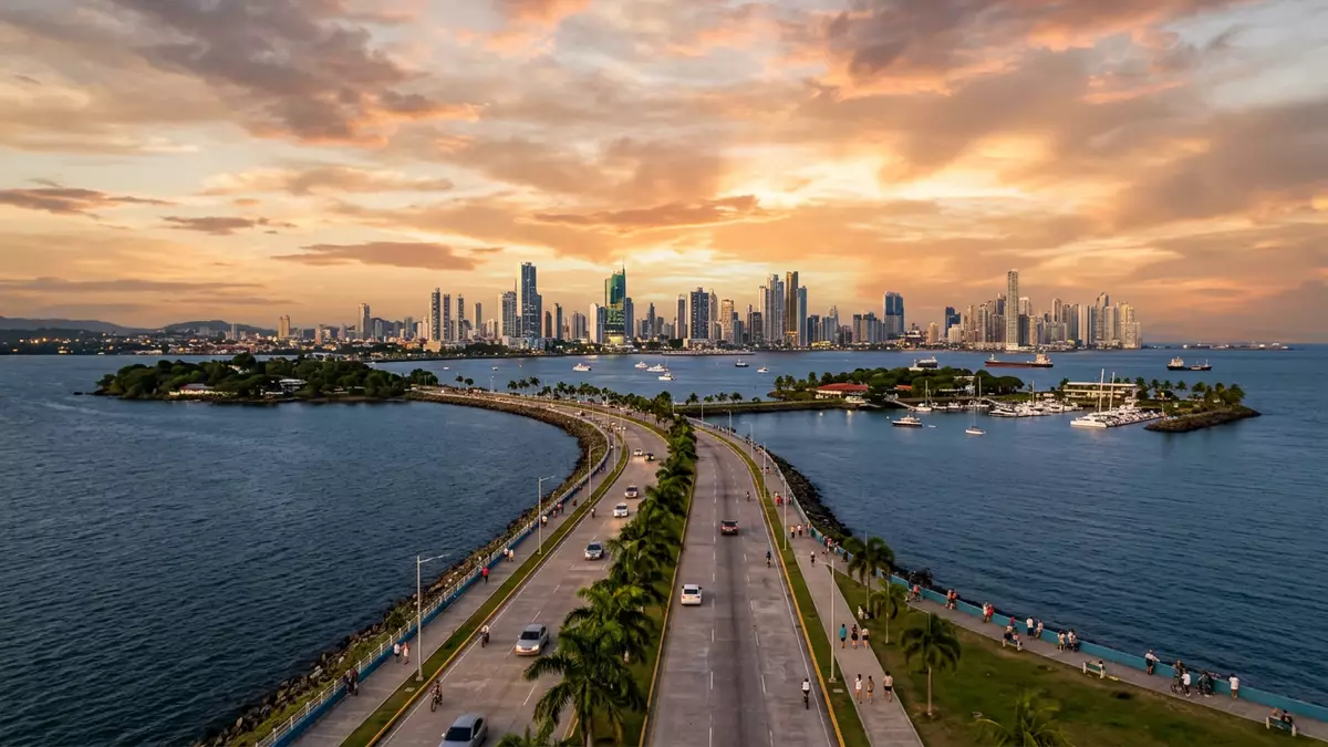
Calzada de Amador is the long seafront road and promenade that stretches from Panama-Stadt out into the Pacific, carrying the city onto a chain of small islands at the mouth of the Panama Canal. Built with material excavated during the canal works in the early twentieth century, it links urban Panama with Naos, Perico, Culebra and Flamenco in a single sweep of asphalt, palms and water on both sides.material excavated during the canal
A causeway built from canal rock
Calzada de Amador takes its name from the district of Amador and from the small archipelago it connects just off the mainland at the Pacific entrance to the Panama Canal.connects the mainland with islands The causeway was completed in 1914, at the same time as the canal itself, using rock and earth removed during the great engineering project.using rock excavated during the canal's construction Seen from above it reads as a slender arm of land reaching almost 6 km (about 3.7 miles) into the bay, a man-made line between open water and the sheltered entrance channel.
A four-lane road runs along the spine of the causeway, edged by wide pavements and a separate path for cyclists.a road with pedestrian and cycle paths Palm trees, low planting and scattered sculptures break up the long perspective, while occasional lay-bys and small parking areas give direct access to the shoreline. The structure also functions as a breakwater for the canal entrance, so ships waiting offshore shelter behind the band of rock as they line up to transit the locks.serves as a breakwater for the entrance
Islands, marinas and wide Pacific views
From the mainland end near the former Canal Zone, Calzada de Amador steps out in stages to Naos, Perico, Culebra and Flamenco, the low Causeway Islands scattered just beyond the city shoreline.Causeway Islands linked to the mainland Each island carries its own cluster of buildings, ranging from marinas and yacht clubs to waterfront restaurants, small shopping areas and piers for tour boats. The road runs through them in sequence, so a walk or ride along the causeway becomes a tour of successive headlands, each with its own angle on the water.
On one side lies the broad curve of the Bay of Panama, with the high-rise silhouette of Panama-Stadt stretching along the shore; on the other stands the canal entrance with container ships, cruise vessels and tugs moving in slow procession towards the Bridge of the Americas.views of the canal entrance and skyline From the outer islands there are also long views towards Taboga Island on clear days, and closer in, over the low hills of Ancón and the port installations on the canal banks. Marinas line parts of the inner shores, their masts forming a dense vertical pattern against the horizontal line of the causeway itself.
From military edge to waterfront promenade
For much of the twentieth century the Causeway Islands were part of the Panama Canal Zone, and fortifications were constructed here to protect the Pacific entrance to the waterway.fortifications built to protect the canal Gun emplacements and concrete platforms still survive in places, relics of a period when the islands formed part of a defensive ring rather than a leisure district. After control of the zone returned to Panama, those military structures were dismantled or left as shells, and the land beside them saw new marinas, port facilities and visitor infrastructure take shape.development along the causeway and islands
Closer to the mainland end, one of the most recognisable buildings on Calzada de Amador is the colourful Biomuseo, designed by architect Frank Gehry as a museum of biodiversity.Biomuseo by Frank Gehry Its angular roofs in bright colours sit beside the causeway, visible from passing ships and from the city shore. Near it, the Punta Culebra Nature Centre presents marine and coastal environments on a small peninsula, adding another layer of educational and scientific presence next to the marinas and promenades.Punta Culebra Nature Center and Biomuseo
Visiting Calzada de Amador: what travellers from Western Europe should know
- Calzada de Amador extends south-west from Panama-Stadt’s district of Ancón towards the Pacific entrance of the Panama Canal, linking the mainland with Naos, Perico, Culebra and Flamenco islands.
- The terrain is flat and fully paved, with a multi-lane road, long pavements and a separate path for cyclists, so movement is along level surfaces rather than steep climbs.
- Calzada de Amador lies in Panama, where the official language is Spanish and the currency is the balboa, which is pegged to and circulates alongside the US dollar.
- From Ancón and the city’s downtown districts, Calzada de Amador is reached by road; taxis, buses and private vehicles follow Avenida Amador out towards the islands along the causeway.
- Entry requirements depend on your nationality; UK travellers can check the FCDO travel advice at gov.uk/foreign-travel-advice, Irish travellers the Department of Foreign Affairs at ireland.ie.
Searching for Calzada de Amador on social platforms
These links open searches for Calzada de Amador on each platform.Frequently asked questions about Calzada de Amador
Where is Calzada de Amador?
Calzada de Amador is a causeway in Panama-Stadt, Panama, stretching from the district of Ancón at the Pacific entrance of the Panama Canal to Naos, Perico, Culebra and Flamenco islands.
What can visitors expect along Calzada de Amador?
Visitors find a long waterfront road with pavements and a cycle path, marinas, restaurants, small shopping areas, museum buildings such as the Biomuseo and broad views of the city skyline and canal entrance.
What makes Calzada de Amador distinctive compared with other waterfront areas?
Calzada de Amador stands out because it is built from Panama Canal excavation rock and runs as a single causeway linking the mainland with several Pacific islands while doubling as a breakwater for the canal entrance.


