
Calzada de Amador, the Panama-Stadt causeway over the Pacific
Published on 09/09/2026 at 21:56 | Editorial responsibility: Rafael Müller, Editor-in-Chief AD HOC NEWS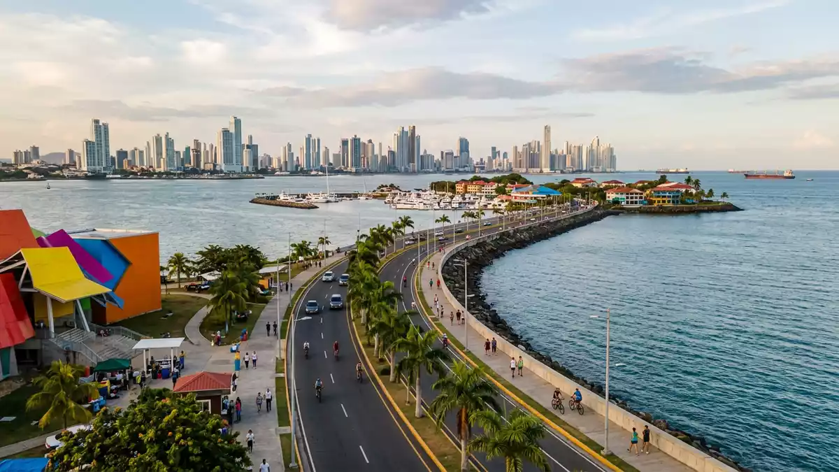
Calzada de Amador is the long waterfront causeway in Panama-Stadt that carries the city out over Panama Bay towards the Pacific entrance of the Panama Canal, linking the mainland with a small archipelago of low islands in a single sweep of reclaimed land and road. Built in the early twentieth century using rock excavated from the canal’s Culebra Cut, it turns canal engineering spoil into a seafront promenade where water flanks the roadway on both sides.
A man-made arm reaching into Panama Bay
Calzada de Amador begins on the mainland shore of Panama-Stadt and extends for several kilometres across Panama Bay, joining the city to the islands of Naos, Perico, Culebra and Flamenco that sit by the Pacific entrance to the canal. The causeway itself is a raised strip of land and asphalt laid over a core of excavated rock and earth, a breakwater structure that shields the canal approach from the open bay while also serving as a transport route.Built in 1913 with rock from the Culebra Cut and extended to connect the four islands, it forms a single continuous line of land between the city and the archipelago.
Seen on a map or from the air, Calzada de Amador reads as a slender arm projecting from the edge of Panama-Stadt into the bay, with the Pacific side on one flank and the sheltered entrance channel to the canal on the other. The road surface carries motor traffic and cycles, while parallel stretches of waterfront create space for walking beside the water. Palms and other coastal planting punctuate the edges of the carriageway and paths, and the slight curvature of the causeway gives changing perspectives on the canal approaches and the city skyline.Around 18 million cubic metres of rock were used in the original construction, underlining the scale of the canal earthworks that supplied its material.
From fortified canal zone to urban waterfront
For much of the twentieth century, the islands connected by Calzada de Amador formed part of a United States military complex known as Fort Amador, established to protect the Pacific entrance to the Panama Canal. Batteries, service roads and other installations occupied the island slopes and waterfronts, reflecting the strategic importance of controlling the canal mouth during the era of the Panama Canal Zone.Fort Amador was created to guard the canal entrance and used the linked islands as a defensive platform overlooking the shipping lanes.
Later in the century the canal zone and its associated bases reverted to Panama under the Torrijos–Carter Treaties, and the defensive role of Fort Amador was wound down. The land along Calzada de Amador and the islands themselves shifted towards civilian use, with marinas, leisure facilities and promenade spaces replacing or incorporating parts of the former military infrastructure. On Naos, Perico, Culebra and Flamenco, traces of earlier fortifications remain visible as scattered structures beside newer buildings, a reminder that the present-day waterfront grew out of a defensive landscape.Military installations once lined the islands, and the change in function over the years is part of the wider story of the canal zone’s transformation.
Waterfront views at the mouth of the canal
Calzada de Amador lies at a point where several major elements of Panama’s geography come together: the Pacific shore of Panama-Stadt, the entrance channel of the Panama Canal and the open waters of Panama Bay. Walking or travelling along the causeway brings a sequence of views, from the low skyline of the islands to the distant span of the Bridge of the Americas and the ships waiting near the canal approaches. The alignment of the causeway between mainland and islands gives clear sight lines both towards the city and out across the bay.
Because the causeway connects multiple islands in a line, the scenery alters from one stretch to the next. Some segments frame the towers of Panama-Stadt across the water, while others open towards the wider expanse of the Pacific beyond the bay. The breakwater foundations shape the edge profile, with stone and concrete embankments dropping to the sea and occasional small inlets between the roadway and the island shores.Views along the causeway take in the canal entrance and city skyline, making the line of Calzada de Amador a natural vantage route for observing both maritime traffic and Panama-Stadt’s urban front.
Visiting Calzada de Amador: what travellers from Western Europe should know
- Calzada de Amador runs south-west from central Panama-Stadt towards the Pacific entrance to the Panama Canal, linking the mainland with the islands of Naos, Perico, Culebra and Flamenco by road.
- The terrain along the causeway is level and paved, with long stretches of roadway and promenade beside the water and occasional gentle gradients as the route passes onto and across the low islands.
- The official language is Spanish and the currency is the Panamanian balboa, which circulates alongside the United States dollar in everyday transactions.
- Entry requirements depend on your nationality; UK travellers can check the FCDO travel advice at gov.uk/foreign-travel-advice, Irish travellers the Department of Foreign Affairs at ireland.ie.
Searching for Calzada de Amador on social platforms
These links open searches for Calzada de Amador on each platform.
Frequently asked questions about Calzada de Amador
Where is Calzada de Amador located?
Calzada de Amador is in Panama-Stadt on the Pacific shore of Panama, extending from the mainland across Panama Bay to the islands of Naos, Perico, Culebra and Flamenco by the Panama Canal entrance.
What can visitors expect along Calzada de Amador?
Visitors find a paved causeway with road and promenade sections beside the water, linking several small islands and offering changing views towards the canal approaches, the Bridge of the Americas and the Panama-Stadt skyline.
What makes Calzada de Amador distinctive among Panama-Stadt’s waterfronts?
Calzada de Amador is distinctive as a man-made breakwater built from Panama Canal excavation spoil that doubles as a transport route and promenade, carrying the city out to former canal-zone islands that once formed part of Fort Amador and now function as a civilian waterfront.


