
Calzada de Amador: Panama-Stadt’s Pacific causeway of rock and islands
Published on 09/08/2026 at 16:11 | Editorial responsibility: Rafael Müller, Editor-in-Chief AD HOC NEWS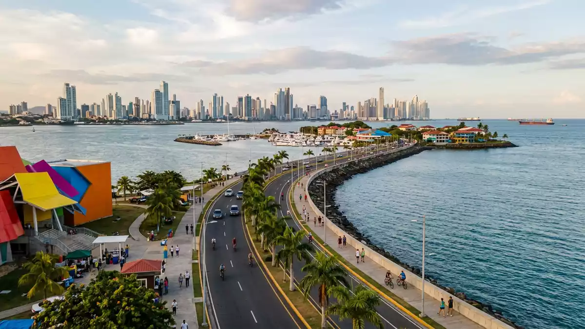
Calzada de Amador in Panama-Stadt is a long man-made causeway of rock and asphalt that carries a waterfront road out into the Pacific Ocean, linking the city to offshore islands at the southern entrance to the Panama Canal. Built in the early twentieth century using material excavated during construction of the canal, it has shifted from military breakwater to waterfront promenade, with Panama’s skyline on one side and the open bay on the other.
From canal earthworks to Pacific causeway
Calzada de Amador was constructed in 1913 by the United States administration using rock and soil taken from the Culebra Cut during the building of the Panama Canal, forming a substantial breakwater at the canal’s Pacific entrance.Built in 1913 with rocks from the Culebra Cut The causeway extends for about 6 km (3.7 miles) from the mainland, creating a narrow strip of land between the city and the bay that functions both as sea defence and as a road.The road extends 6 kilometres into the Pacific Ocean
The work transformed what had been open water into a long embankment reaching towards a small archipelago. According to local descriptions, the Calzada de Amador connects the continental shore near Ancón district with the islands of Naos, Perico and Flamenco, forming a continuous route from city edge to island waterfront.La Calzada de Amador conecta la parte continental con las islas Naos, Perico y Flamenco For much of the twentieth century the area formed part of a United States military complex known as Fort Amador, created to defend the Pacific entrance to the canal, and substantial fortifications were built along the causeway.Fortifications were erected here to protect the southern entrance to the Panama Canal
A road of islands, marinas and museums
From the mainland end near Panama-Stadt the causeway runs over water towards Naos, Perico, Culebra and Flamenco, linking a chain of small Pacific islands that now carry a mix of scientific, residential and leisure uses.A scenic road connecting four small islands Naos is home to facilities including a Smithsonian laboratory and the Punta Culebra Nature Center, while Perico and Flamenco have marinas, boat services and waterfront areas with restaurants and shops.The road runs from the mainland out to Naos, Culebra, Perico and Flamenco
The mainland end of Calzada de Amador holds the Biomuseo, a science and biodiversity museum designed by architect Frank Gehry, whose angular, brightly coloured roofs form a striking landmark at the start of the causeway.Frank Gehry's only Latin American building stands at the causeway's entrance Further along, Flamenco Island contains a large marina and a ferry terminal where boats depart to destinations such as Taboga Island in the Gulf of Panama, making the causeway both a leisure strip and a transport hub.Ferries to Taboga depart from Flamenco Marina
Promenade between skyline, ships and sea
Calzada de Amador is laid out as a waterfront road with a paved pedestrian and cycling route alongside it, giving visitors a front-row vantage point over the entrance to the Panama Canal, the Bridge of the Americas and the high-rise profile of Panama-Stadt.The 6 km-long stretch offers vantage points over the canal and skyline The walking and jogging paths run beside rock armour and low sea walls, so the water of the bay lies just beyond the edge of the promenade.Trails for jogging and biking run along the causeway
Along its length, the causeway carries a sequence of recreational installations including restaurants, bars and a convention centre, as well as areas used for walking, cycling and informal sport.La calzada cuenta con numerosas instalaciones recreativas At several points the view opens towards the channel where large container ships line up to enter or leave the canal, and towards the distant hills and islands beyond the bay, making the promenade a continuous balcony between city, harbour and Pacific horizon.
Visiting Calzada de Amador: what travellers from Western Europe should know
- Calzada de Amador runs from the western side of Panama-Stadt towards the Pacific entrance of the Panama Canal, starting near the Ancón area and reaching the islands of Naos, Perico, Culebra and Flamenco.
- The terrain is almost entirely level, with a paved roadway and adjacent pavements and cycling paths; stretches of the promenade are exposed to sun and sea breezes, and the full length is several kilometres.
- From the mainland section, Metro Line 1 of Panama City’s system serves Albrook station, from where local bus route C850 connects towards Calzada de Amador via the Metro-Albrook bus station.
- English and Spanish are widely present in Panama-Stadt; the official language of Panama is Spanish and the currency is the Panamanian balboa, which circulates alongside the United States dollar.
- Entry requirements depend on your nationality; UK travellers can check the FCDO travel advice at gov.uk/foreign-travel-advice, Irish travellers the Department of Foreign Affairs at ireland.ie.
Searching for Calzada de Amador on social platforms
These links open searches for Calzada de Amador on each platform.
Frequently asked questions about Calzada de Amador
Where is Calzada de Amador?
Calzada de Amador is a causeway in Panama-Stadt that extends from the mainland near the Ancón district towards the Pacific entrance of the Panama Canal, reaching the islands of Naos, Perico, Culebra and Flamenco.
What can visitors expect on a visit to Calzada de Amador?
Visitors encounter a long waterfront road with pavements and cycling paths, lined with recreational venues and marinas, and views towards the canal entrance, the Bridge of the Americas and the city skyline.
What makes Calzada de Amador distinctive among Panama-Stadt’s waterfronts?
Its distinctive character lies in the combination of its origin as a 6 km breakwater built from canal excavation rock, its connection to offshore islands and its role as a continuous promenade between city towers, Pacific bay and the Panama Canal’s southern gateway.


