

Bay of Fundy’s colossal tides at Saint John
Published on 08/23/2026 at 11:06 | Editorial responsibility: Rafael Müller, Editor-in-Chief AD HOC NEWS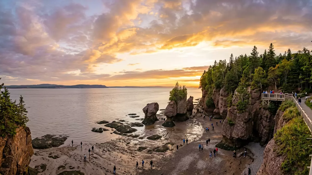
Along the Atlantic coast of eastern Canada, the Bay of Fundy forms a deep, tapering inlet between New Brunswick and Nova Scotia where the ocean rhythm drives some of the planet’s most extreme tides. The bay’s funnelled shape and long, narrow reach combine with the timing of lunar tides to produce water level changes that can reach more than 16 m (over 50 ft) between low and high tide at the head of the bay. Visible from Saint John and other communities along its shore, this tidal pulse has carved cliffs, mudflats and river gorges into a distinctive maritime landscape that continues to evolve with every cycle.
A funnel-shaped bay with colossal tides
The Bay of Fundy stretches for hundreds of kilometres inland from the open Atlantic, narrowing and shallowing as it approaches its head and branching into smaller arms such as Chignecto Bay and Minas Basin. Steep bedrock cliffs, in places rising around 60 m (about 200 ft), line long reaches of the shore and channel the water into progressively tighter corridors before it separates into these inner basinssteep bedrock cliffs up to 200 feet. Coastal outcrops of red sandstone and shale erode under waves and rain, sending fine sediment into the bay that settles in broad expanses of mud exposed at low tide.
The extraordinary tidal range in the Bay of Fundy arises from the interplay between its shape and tidal resonance, the synchronisation of the bay’s natural sloshing period with the timing of incoming ocean tides. Under typical conditions, high tide at the head of the bay can stand about 17 m (roughly 56 ft) higher than low tidehigh tide at the head of the Bay of Fundy. In one tidal cycle, around 100 billion tonnes of seawater flow in and out of the bay, with two high tides and two low tides every lunar dayaround 100 billion tonnes of water flows in and out.
Tidal resonance and a half?graben basin
Beneath the surface, the Bay of Fundy occupies a structural depression geologists term the Fundy Basin, part of a half?graben system bounded by major faults along its north?western marginunderlain by a half-graben with key faults. These faults, of Palaeozoic or older origin, were reactivated as the Atlantic Ocean began to open during the early Mesozoic, creating a rift valley that was later infilled by Triassic continental sediments. The result is a deep basin whose depth and outline influence the way water moves along its length.
As rising Atlantic tides cross the edge of the continental shelf into the shallow Gulf of Maine, they travel as long waves towards the head of the bay, reflect, and return seaward with a speed tied to water deptha long wave to the head of the Bay of Fundy. The whole Bay of Fundy–Gulf of Maine system has a natural oscillation period of just over 13 hours, nearly matching the roughly 12.4?hour forcing of the dominant North Atlantic tidesa natural period of oscillation of a little over 13 h. This near resonance means that successive tidal pulses enter a bay whose water is already in motion, amplifying the vertical range until, in places such as Burntcoat Head, water levels can change by more than 16 m between low and high tidetidal range up to 12 meters.
Saint John, reversing rapids and Fundy’s coastal landscape
The Bay of Fundy’s inner shores host several communities and protected areas where the tides shape everyday scenery. The waters meet the Saint John River at a narrow gorge known as the Reversing Rapids near the city of Saint John, creating whirlpools and rapids as successive high tides push against river flow. This interaction between ocean and river is one of several phenomena tied to Fundy’s tides, alongside tidal bores in estuaries and large whirlpools such as Old Sow farther south in the bayReversing Falls, tidal bore, Old Sow Whirlpool.
Fundy National Park on the New Brunswick coast preserves forested highlands, valleys and a stretch of shoreline where the high tidal range is readily seen in exposed foreshore and rapidly shifting water levelsFundy's tides are the highest in the world. Farther up the bay towards Chignecto Bay, sculpted sea stacks at Hopewell Rocks demonstrate how repeated immersion and exposure erode coastal sandstone into natural pillars and arches that visitors can walk around at low tide and see partly submerged when the tide returnsThe Hopewell Rocks Provincial Park.
Visiting Bay of Fundy: what travellers from Western Europe should know
- The bay lies between New Brunswick and Nova Scotia on Canada’s Atlantic seaboard, with Saint John on the north-western shore as a major port city connected by road and regional flights.
- Coastal viewpoints and river gorges near Saint John include stepped paths, exposed rock and occasional steep gradients, so footwear suitable for uneven ground is helpful on shore walks.
- Shorelines around the bay feature expanses of soft mud at low tide, with marked differences between high- and low-water levels along cliffs and harbour walls.
- The official languages in this part of Canada are English and French, and the currency is the Canadian dollar.
- Entry requirements depend on your nationality; UK travellers can check the FCDO travel advice at gov.uk/foreign-travel-advice, Irish travellers the Department of Foreign Affairs at ireland.ie.
Searching for Bay of Fundy on social platforms
These links open searches for Bay of Fundy on each platform.Frequently asked questions about Bay of Fundy
Where is the Bay of Fundy in relation to Saint John?
The bay lies between New Brunswick and Nova Scotia on the Atlantic coast of Canada, with the city of Saint John positioned on its north-western shore.
What can travellers expect to see on a visit?
Travellers encounter steep cliffs, wide mudflats and marked changes in water level between low and high tide, along with tidal phenomena such as rapids where the bay meets rivers.
What makes the Bay of Fundy distinctive among coastal inlets?
Its funnel shape, deep rift-basin geology and near-resonant tidal period combine to produce some of the world’s largest tidal ranges and visible coastal landforms shaped by repeated immersion and exposure.


