
Ayeyarwady River bending past the temple plain of Bagan
Published on 08/27/2026 at 07:25 | Editorial responsibility: Rafael Müller, Editor-in-Chief AD HOC NEWS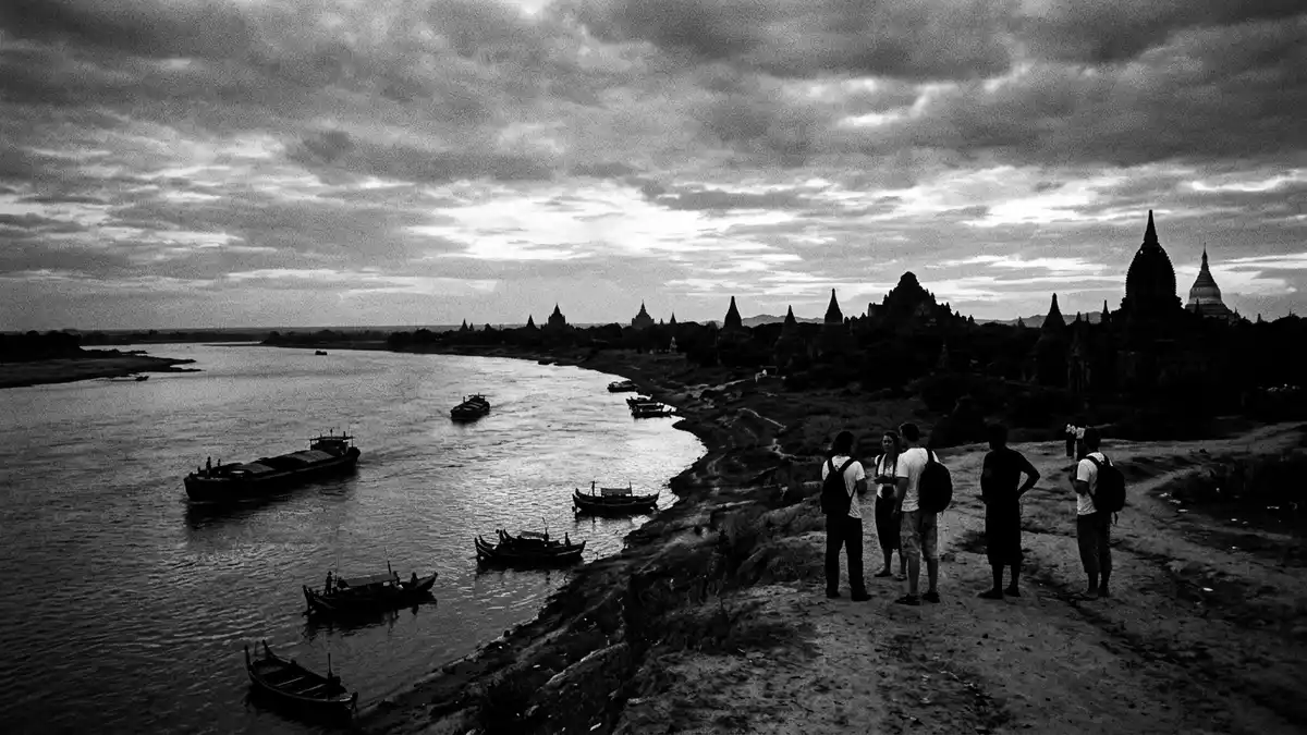
Ayeyarwady River, known in older English texts as the Irrawaddy River, flows through the centre of Myanmar and makes a sweeping bend beside the temple plain of Bagan. Along this reach the broad waterway and the expanse of Buddhist monuments share a single landscape, with the ancient city spread across the slightly raised ground on the eastern bank.
A river at the heart of Myanmar’s landscape
Ayeyarwady River is the principal river system of Myanmar, running roughly north–south across the country before reaching a wide delta on the Andaman Sea.principal river of Myanmar It is formed by the confluence of the N’mai and Mali rivers in Kachin State in the far north, then continues through successive climatic zones towards the central dry region and beyond.formed by the confluence of the Nmai and Mali rivers Along its course Ayeyarwady River passes major towns including Mandalay and Bhamo, and it flows beside Bagan where the river and the temple plain occupy the same stretch of central Myanmar.
The scale of Ayeyarwady River becomes part of the geography of Bagan. From the higher ground of Old Bagan the river appears as a wide channel bordered by low banks, with boat landings and informal access tracks descending from the terraces towards the water. The Bagan Archaeological Zone extends for many kilometres along this river margin, with Nyaung U to the north and New Bagan to the south marking the limits of the main concentration of monuments.serial property on a bend of the Ayeyarwady River
Bagan on the eastern bank of Ayeyarwady River
Bagan is an ancient city in the Mandalay Region of Myanmar and holds UNESCO World Heritage status for its dense cluster of Buddhist monuments across the plains.Bagan Archaeological Zone in Upper Burma The archaeological zone occupies a large area of low ground on a bend of Ayeyarwady River, centred on Old Bagan and including Nyaung U and New Bagan as its main settlements. This zone is characterised by brick temples, pagodas and stupas rising above fields and tracks, with the river forming a broad boundary to the west.
Bagan stands on the eastern bank of Ayeyarwady River in the central dry zone of Myanmar, where the river has carved a sweeping curve and the alluvial plain opens into terraces and low bluffs that descend towards the water.established on the eastern bank of the Irrawaddy River At this bend a dense cluster of monuments extends along the river for a considerable distance and reaches inland, creating a landscape in which the river and the temples remain in view of each other across much of the site.dense cluster of monuments along the river
Experiencing Ayeyarwady River at Bagan
At Bagan, Ayeyarwady River offers long views over water and brick architecture in combination. From the higher ground of the temple plain, the river sits below a series of terraces and embankments, giving vantage points over boat landings, sandbanks and the distant western side of the bend. Access to the river is generally via earthen tracks or steps descending from Old Bagan towards simple landings on the bank, where surfaces can be uneven and shaped by seasonal levels of water.access to the river via earthen tracks or steps
The presence of Ayeyarwady River also frames movement through the archaeological landscape. Roads and tracks in and around Bagan often run parallel to the river or descend towards jetties and small landings, and many viewpoints across the temples align with the gentle curve of the waterway. Travellers encounter a broad river bordered by low ground, with pagodas and stupas rising above surrounding fields and scattered trees on the slightly higher terrain, while the river itself widens into a broad reach beside the city.broad bend beside the temple plain
Visiting Ayeyarwady River: what travellers from Western Europe should know
- Ayeyarwady River passes directly beside Bagan in central Myanmar, with the ancient city occupying the eastern bank; access is commonly via Bagan’s Nyaung U area and local roads leading towards river landings.
- The terrain between the temple plain and Ayeyarwady River includes terraces, low bluffs and informal tracks or steps down to boat landings, where ground can be uneven and may require careful footing.
- Bagan lies within the Bagan Archaeological Zone on the river bend, so visiting Ayeyarwady River often involves moving between brick temples and modest jetties along a network of unsurfaced paths.
- The official language is Burmese and the currency is the Myanmar kyat.
- Entry requirements depend on your nationality; UK travellers can check the FCDO travel advice at gov.uk/foreign-travel-advice, Irish travellers the Department of Foreign Affairs at ireland.ie.
Searching for Ayeyarwady River on social platforms
These links open searches for Ayeyarwady River on each platform.
Frequently asked questions about Ayeyarwady River
Where is Ayeyarwady River in relation to Bagan?
Ayeyarwady River runs through central Myanmar and at Bagan it forms a broad bend beside the Bagan Archaeological Zone, with the city on the eastern bank.
What should visitors expect when reaching the river at Bagan?
Visitors encounter a wide waterway below terraces and low bluffs, with earthen tracks or steps leading to simple boat landings and views across brick temples and fields.
What makes Ayeyarwady River distinctive at Bagan?
The distinctive character of Ayeyarwady River at Bagan lies in its sweeping curve alongside a vast concentration of Buddhist monuments, where the river and temple plain share a single landscape.


