
Angkor Thom, the walled royal city of Siem Reap
Published on 09/04/2026 at 12:08 | Editorial responsibility: Rafael Müller, Editor-in-Chief AD HOC NEWS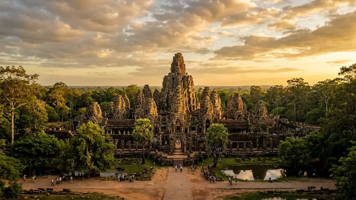
Angkor Thom near Siem Reap in Cambodia is a vast walled royal city whose towers, terraces and palace ruins form a single monumental landscape in the forest. Built as the capital of the Khmer Empire under King Jayavarman VII in the late twelfth century, it gathers religious, ceremonial and residential structures inside one square enclosure.
The Great City: layout and origins
Angkor Thom occupies a square plan enclosed by high laterite walls and a broad moat, defining a royal city that extends across several square kilometres of lowland north of Siem Reap. At its centre stands the Bayon, Jayavarman VII’s state temple, surrounded by a network of avenues, terraces and palace compounds that mark out the urban core of the Angkor period.Angkor Thom was the last capital of the Khmer Empire The city is traditionally dated to the late twelfth century, when Jayavarman VII established his new seat of power and integrated earlier temples into his redesigned royal centre.Jayavarman VII reshaped Angkor Thom in the late twelfth century
The moat and walls are punctuated by monumental gates on each side, reached by causeways lined with sculpted figures that once bore naga serpents. Inside the walls, the Bayon sits almost exactly at the city’s centre, its dense cluster of towers carrying enigmatic stone faces that look out along the main processional routes.The Bayon is Angkor Thom’s defining central temple Around it lie the remains of the Royal Palace, the stepped temple of Baphuon and the raised platforms that formed the city’s principal ceremonial square.
Stone faces, terraces and the royal square
The Bayon dominates the visual experience of Angkor Thom. From its elevated galleries, dozens of towers rise, each carrying carved faces associated with Avalokiteshvara or the king himself, arranged so that many are visible at any angle among the stonework. Their height and concentration create a layered skyline of sandstone and laterite that distinguishes Angkor Thom from other temple cities in the Angkor Archaeological Park.The Bayon’s towers carry numerous carved faces At ground level, long bas-reliefs narrate battles, everyday scenes and processions, linking the temple’s religious role with the civic life of the capital.
North of the Bayon, the Royal Square brings together the Terrace of the Elephants, the Terrace of the Leper King and the frontage of the Baphuon temple in a single ceremonial axis.The Terrace of the Elephants formed part of the royal ceremonial precinct The Terrace of the Elephants stretches for about 300 m (984 ft) along the western edge of the square, its laterite core faced with sandstone panels carved with elephants, garudas and hunting scenes.The Terrace of the Elephants is about 300 metres long This raised platform fronted the Royal Palace compound and provided access to the ceremonial heart of the city, while the neighbouring Terrace of the Leper King rises higher, its own carvings packed into a narrower footprint.
Angkor Thom within the wider Angkor landscape
Angkor Thom stands within the Angkor Archaeological Park, north of Angkor Wat and west of the Siem Reap River, sharing both its setting and its sandstone and laterite construction with the wider Angkor complex.Angkor Thom lies on the west bank of the Siem Reap River The city’s gates connect by road and paths to Angkor Wat, Ta Prohm, Preah Khan and other temples, making Angkor Thom one piece in a larger network of religious and royal sites that developed between the ninth and fifteenth centuries.Angkor Thom forms part of the Angkor Archaeological Park
Within its walls, Angkor Thom gathers monuments from different periods of Khmer history, including earlier structures integrated into Jayavarman VII’s city layout and later additions by his successors. The Royal Palace area retains Phimeanakas, a temple-mountain, and traces of wooden halls that once stood on stone bases, while around the perimeter archaeologists have identified residential quarters and smaller shrines. The park as a whole is inscribed on the UNESCO World Heritage List, reflecting both the artistic detail of Angkor Thom’s carvings and the ambition of its urban planning.
Visiting Angkor Thom: what travellers from Western Europe should know
- Angkor Thom lies inside the Angkor Archaeological Park north of Siem Reap, accessed by roads leading to the South Gate, Victory Gate and other entrances from the town and neighbouring temples.
- The walled city covers several square kilometres, and visiting its main monuments involves walking along uneven stone terraces, climbing steep temple stairways and crossing causeways over the moat.
- Angkor Thom forms part of a wider concentration of temples and ruins; Angkor Wat, Ta Prohm, Preah Khan and other major sites lie within a short drive or cycle ride of the city’s gates.
- The official language of Cambodia is Khmer and the currency is the Cambodian riel, though other currencies circulate alongside it in Siem Reap and the Angkor area.
- Entry requirements depend on your nationality; UK travellers can check the FCDO travel advice at gov.uk/foreign-travel-advice, Irish travellers the Department of Foreign Affairs at ireland.ie.
Searching for Angkor Thom on social platforms
These links open searches for Angkor Thom on each platform.Frequently asked questions about Angkor Thom
Where is Angkor Thom and what kind of place is it?
Angkor Thom is a walled royal city within the Angkor Archaeological Park near Siem Reap in Cambodia, enclosed by a moat and monumental gates.
What should visitors expect during a visit to Angkor Thom?
Visitors encounter temple towers with carved faces, long stone terraces, palace ruins and extensive walking routes across uneven ground and stairways inside the city walls.
What makes Angkor Thom distinctive among Angkor’s sites?
Angkor Thom is distinctive because it preserves an entire planned royal city, dominated by the Bayon temple and the Terrace of the Elephants along its main ceremonial square.


