
Acadia National Park’s granite coast and mountain light
Published on 09/14/2026 at 15:29 | Editorial responsibility: Rafael Müller, Editor-in-Chief AD HOC NEWS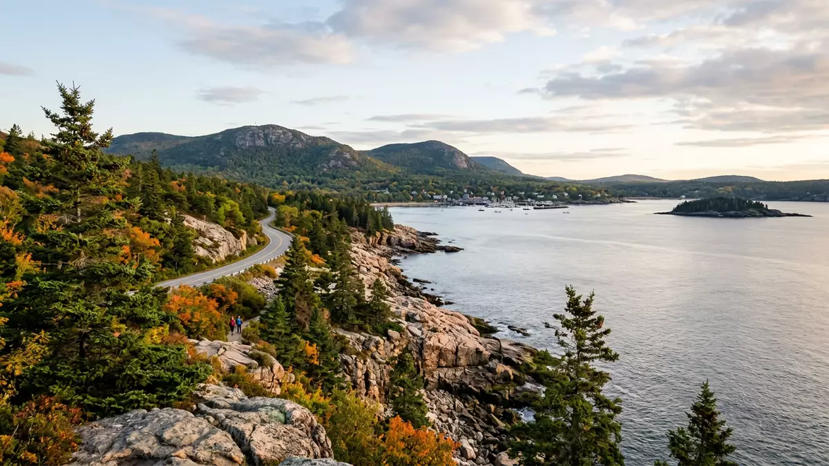
Acadia National Park on the coast of Maine brings granite mountains, rocky Atlantic shoreline and forested valleys together in a compact, carefully preserved landscape centred on Mount Desert Island near Bar Harbor. The park in its present form grew from an initial 6,000 acres protected in 1916 and now extends across tens of thousands of acres of islands and peninsulas on the state’s eastern seaboard.
Granite mountains above the Atlantic
Acadia’s geography is defined by a chain of rounded granite summits rising directly from the sea, with slopes descending towards coves and inlets where waves break against rock. The best known of these heights is Cadillac Mountain, a summit reaching about 466 m (1,530 ft) above sea level and standing as the highest point on the North Atlantic coastline of the United States.Cadillac Mountain summit road From its upper slopes the view takes in the outer islands of Frenchman Bay, the wooded interior of Mount Desert Island and, on clear days, distant ridges further inland.
The rocks that form these summits record a geological story stretching back hundreds of millions of years. Mud, sand and volcanic ash laid down in an early ocean were transformed into formations such as the Ellsworth Schist and the Bar Harbor Formation, then intruded by granites that are around 420 million years old.Ellsworth Schist and Bar Harbor Formation Glacial erosion later carved valleys, basins and the present shoreline, leaving a combination of smooth bedrock, perched boulders and cliffs now visible on coastal walks and mountain trails.
From early monument to Acadia National Park
The protected landscape around Bar Harbor began its formal life in the early twentieth century when President Woodrow Wilson created Sieur de Monts National Monument in 1916, safeguarding an initial tract of land on Mount Desert Island.Sieur de Monts National Monument 1916 In 1919 this area was designated Lafayette National Park, and in 1929 it received the name Acadia National Park, reflecting the wider historical association of the region with the French colonial name Acadia.
The park has grown through donations and acquisitions into an area of more than 48,000 acres spread across Mount Desert Island, the Schoodic Peninsula, Isle au Haut and a constellation of smaller coastal islands.more than 48,000 acres on Mount Desert Island and beyond Figures such as George B. Dorr and John D. Rockefeller, Jr. played central roles in assembling land and shaping infrastructure, with Rockefeller in particular known for financing and donating an extensive network of carriage roads. The National Park Service administers Acadia, with headquarters at Bar Harbor and responsibilities extending from ecological integrity to cultural history across this archipelago landscape.National Park Service administration from Bar Harbor
Carriage roads, motor roads and coastal highlights
One of Acadia’s most distinctive features is its system of historic motor roads and car-free carriage roads threading through forest and along shore. Travellers encounter paved routes such as the Park Loop Road, a scenic drive of about 27 miles that connects major viewpoints and coastal sections on Mount Desert Island, as well as gravel carriage roads built in the early twentieth century for horse-drawn vehicles and later enjoyed by walkers and cyclists.historic motor roads and carriage roads These carriage roads cross streams and valleys on stone bridges and pass through forest openings where granite outcrops break the tree cover.
The shoreline itself ranges from open surf to sheltered coves and tidal flats. Named places include Sand Beach, a small pocket of sand framed by cliffs, and Thunder Hole, where waves entering a narrow coastal indentation can produce a resonant crash in certain conditions.Sand Beach and Thunder Hole Inland, an array of hiking trails link summits, lakes and woodlands, some following rocky ridges with views over Frenchman Bay and others winding through forest near ponds and wetlands.
Visiting Acadia National Park: what travellers from Western Europe should know
- Acadia National Park lies on the coast of Maine in the United States, with its main section on Mount Desert Island near the town of Bar Harbor. The National Park Service lists Bar Harbor as the nearest significant community.
- The terrain combines steep mountain paths, uneven rocky shoreline and forest tracks, and many summit routes involve sustained climbing over stone steps and bedrock.
- The park extends across Mount Desert Island, the Schoodic Peninsula, Isle au Haut and offshore islands, so visiting different sectors involves travelling by road or, for Isle au Haut, by boat.
- English is the official language and the currency is the US dollar.
- Entry requirements depend on your nationality; UK travellers can check the FCDO travel advice at gov.uk/foreign-travel-advice, Irish travellers the Department of Foreign Affairs at ireland.ie.
Searching for Acadia National Park on social platforms
These links open searches for Acadia National Park on each platform.
Frequently asked questions about Acadia National Park
Where is Acadia National Park located?
Acadia National Park is on the coast of Maine in the United States, centred on Mount Desert Island with its headquarters and nearest major town at Bar Harbor.
What can visitors expect on a visit to Acadia?
Visitors encounter granite mountains, forested valleys, rocky Atlantic shoreline, lakes and an extensive system of motor roads, carriage roads and hiking trails connecting these landscapes.
What makes Acadia National Park distinctive compared with other coastal areas?
The combination of high granite summits such as Cadillac Mountain rising beside the Atlantic, together with historic carriage roads and varied shorelines, gives Acadia a particular character among North American coastal parks.


