
Abel Tasman National Park’s golden coastline from Marahau
Published on 08/27/2026 at 18:55 | Editorial responsibility: Rafael Müller, Editor-in-Chief AD HOC NEWS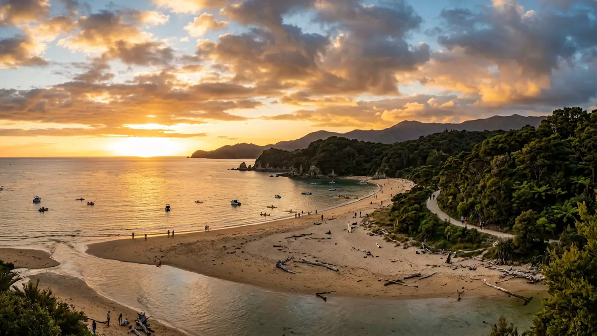
Abel Tasman National Park draws a fine line of golden sand along the north coast of New Zealand’s South Island, with the small settlement of Marahau sitting at its southern gateway.The national park stretches between Golden Bay and Tasman Bay, wrapping bush-covered hills around clear shallows and island-dotted bays. Created in 1942 and named for the seventeenth-century Dutch explorer Abel Janszoon Tasman, it keeps a compact footprint while packing in a dense mix of coastline, forest and estuary.
Golden beaches and a compact coastal wilderness
Abel Tasman National Park covers a little over 200 square kilometres of land, making it the smallest of New Zealand’s national parks in area yet one of its best-defined coastal landscapes. Its boundary hugs a run of bays between Golden Bay / Mohua and Tasman Bay / Te Tai-o-Aorere, where narrow valleys descend from low hills towards sandy inlets and rock platforms.The Department of Conservation locates the park at the top of the South Island, with Motueka, Takaka and Kaiteriteri as the nearest towns.
Much of the shore has a distinctive rhythm: shallow bays backed by regenerating forest, headlands of harder rock and estuaries that open and close with the tide.The Abel Tasman Coast Track follows this line for around 60 km, keeping close to the sea from Marahau in the south to Wainui in the north. Bays such as Anchorage, Torrent Bay, Bark Bay and Awaroa sit along the way, each framed by low ridges and sheltered shallows that have become classic images of the park.
From Marahau into the coastal maze
Marahau stands at the southern entrance to Abel Tasman National Park, where the sealed road ends and the coastal track begins. A Department of Conservation car park and information point mark the formal gateway; a short walk from here takes visitors across a tidal inlet and into the first stretches of native bush. Marahau itself remains a small village with accommodation, cafés and kayaking operators strung along the shoreline, serving as the point where land transport gives way to walking tracks and boat routes.
Beyond Marahau the Abel Tasman Coast Track alternates between forested slopes and open coves, with several sections crossing tidal inlets that expose wide flats of sand and channels at low tide.The track is laid out in sections between bays and coastal access points, making it possible to walk short stretches or link several days on foot. Water taxis use designated landing spots along this coast, so walkers and kayakers can combine boat transfers with sections of the track rather than retracing their steps.
History, protection and coastal culture
Abel Tasman National Park was formally established on 16 December 1942, three centuries after Abel Tasman’s 1642 visit to these shores, under a decision announced by Prime Minister Peter Fraser.Government records from 1942 describe nearly 38,000 acres being reserved for the new park, drawing on state forest, Crown land and existing reserves. Later adjustments defined the current footprint of about 22,530 hectares, which continues to safeguard coastal bush, estuaries and offshore islands.
The park forms part of the wider Nelson Tasman region, with tourism operators based in nearby settlements such as Marahau and Kaiteriteri offering sea kayaking, boat trips and guided walks along the coast. Conservation programmes in the park focus on regenerating native forest and managing introduced species, while tracks and huts maintained by the Department of Conservation support multi-day journeys that have become a hallmark of the area.
Visiting Abel Tasman National Park: what travellers from Western Europe should know
- Abel Tasman National Park lies at the northern end of New Zealand’s South Island, with road access from Nelson to Marahau and further connections to Kaiteriteri and Totaranui.
- The coastal terrain between Marahau and Wainui involves formed walking tracks with some sustained gradients, sections of stepped path and several tidal inlets where routes cross firm sand flats.
- Marahau and Kaiteriteri are the main coastal gateways, with boat operators and sea kayaks providing access to bays such as Anchorage, Bark Bay and Awaroa along the park’s shoreline.
- The official language is English and the currency is the New Zealand dollar.
- Entry requirements depend on your nationality; UK travellers can check the FCDO travel advice at gov.uk/foreign-travel-advice, Irish travellers the Department of Foreign Affairs at ireland.ie.
Searching for Abel Tasman National Park on social platforms
These links open searches for Abel Tasman National Park on each platform.
Frequently asked questions about Abel Tasman National Park
Where is Abel Tasman National Park and how does Marahau relate to it?
Abel Tasman National Park lies on the northern coast of New Zealand’s South Island between Golden Bay and Tasman Bay, with Marahau marking its southern entrance and roadhead.
What can visitors expect when entering the park from Marahau?
Visitors entering from Marahau cross a tidal inlet and follow formed tracks that lead through coastal bush to a succession of bays, estuaries and low headlands.
What makes Abel Tasman National Park distinctive among New Zealand’s national parks?
The park combines a relatively small land area with a continuous coastal track, golden beaches and tidal estuaries, all protected since 1942 under the name of explorer Abel Tasman.


